BOOK YOUR 2021 TRIP AND PAY ZERO DEPOSIT UNTIL 1ST MARCH

Are you desperate to book a walking holiday for 2021 but hesitant due to the uncertainty of how the ongoing COVID crisis will impact your plans?

If you book one of our walking holidays during November and December 2020, there is no need to pay a deposit until 1st March 2021*. No fees will be charged if you choose to cancel before 1st March.

Quote ‘ZERODEP2021’ on the Booking Enquiry Form to qualify for this limited time offer.

*A non-refundable deposit of £75 per person will be required on the 1st March

COVID-19 UPDATE Resuming our walking holidays

Now that the Scottish Government has advised the tourism industry can resume trading from the 15th July (subject to the continued positive progress on suppressing the COVID-19 outbreak), we now look forward to the day when we can once again welcome visitors from both the UK and overseas.  

At WAS & Make Tracks; despite this announcement, we must remain cautious due to a number of factors which must taken into consideration before our walking holidays can resume to any form of normality, including;

1. Quarantine Rules - currently there is no date as to when the 14-day quarantine rule for incoming visitors to the UK will be lifted.

2. B&B guidelines - accommodation providers will be required to adhere to a number of COVID-19 guidelines and recommendations before they will be allowed to reopen.  Not every B&B will be in a position to reopen immediately.

3. Service Providers - currently it is still not possible to eat and drink at the premises of any cafe, restaurant, pub, hotel, etc.  Clearly these services need to be up and running in order for anyone to partake in a successful walking holiday.  This could change by the end of June, however, will likely be limited to outside eating and drinking only (e.g. beer gardens).  It is worth considering that, during periods of bad weather, the idea of having to dine outside is not something most people will welcome.

4. A number of tourism businesses have not yet committed to reopening on the 15th July through fear of being overwhelmed by travellers desperate for an escape after being locked down for so long.  High volumes of visitors at some locations could have a detrimental effect on a walking holiday (e.g. queuing for a meal at the end of a long day on the trail).  By resuming our own walking holidays a short time after the lockdown restrictions are eased, our hope is that the immediate rush will have eased off, allowing our customers to enjoy a more relaxed walk.  This will also allow service providers time to get used to any new COVID related contingencies within their workplace and premises.

While the tourism industry prepares to resume on the 15th July, we must be completely confident that service providers along each of the trails are suitably equipped and prepared to cope with the high influx of visitors who are likely to travel once the lockdown measures are eased. 

With this is mind, our current aim is to resume those walking holidays which are currently due to start on or after the 1st August, unless, for any reason, it is not possible to do so (e.g. if the 14-day quarantine rule for visitors to the UK is still in place, or if there are not enough service providers in operation on that particular trail).  The safety and wellbeing of our customers is the ultimate priority, which will never be compromised. 

It will, of course, still be an option for customers to reschedule their walking holiday to 2021, where we will be happy to carry forward any deposit paid at the time of booking. We completely understand that some clients may wish to postpone their itinerary to new dates, when the COVID-19 crisis is no longer deemed a threat to society. For existing clients, please contact Ross and the team if you wish to discuss your options.

There will undoubtedly be a number of COVID-19 related contingencies in place for some time to come, which we must learn to embed into society and our way of life until such times as the relevant political and scientific bodies across the World see otherwise.  

We are one step closer to re-opening the gate to Scotland’s wonderful and breath taking countryside.  By acting responsibly, with togetherness and in the best interests of every single individual affected by the coronavirus crisis; we can hopefully make not only Scotland, but also the World, a better place.

Best wishes,

Ross Mackey

Book your 2021 Walking Holiday - Book now & pay later

With the 2020 walking season becoming ever more affected by the COVID-19 outbreak, many people are looking to next year to either book or reschedule their Scottish walking holiday. With many of our existing clients looking to move their trip to 2021, demand will undoubtedly increase over the coming weeks and months. We are now taking bookings for 2021 and, for a limited time, you don’t need to pay a deposit until 1st October 2020, or in other words, “book now, pay later”. This offer will be available up to the 31st May.

Coronavirus Update - UPDATED 22ND MAY

At Walk Across Scotland & Make Tracks, our ultimate priority is to protect the best interests of our customers (i.e. to exercise our duty of care), therefore, it is important that our clients have peace of mind in the knowledge that we are doing our very best throughout this most unprecedented situation.  We are provided with Coronavirus updates from the UK & Scottish Governments on a daily basis and, with this information, we take time to carefully consider how any developments could impact each walking holiday. 

Despite the pandemic arguably now more controlled in a number of countries, including the UK; the global impact of the virus remains a very serious situation.  While the Scottish Government has now implemented a four phase plan and route map for restoring the country to some form of normality, this could still change over the coming weeks.  We must also pay serious attention to the restrictions on those who are arriving from overseas, where the current requirement is to immediately self-isolate for 14 days before heading out into the wider society. It is, therefore, extremely important that we implement measures which are most appropriate to the circumstances.  Given the latest announcements from the UK & Scottish Governments, it remains extremely difficult for us to gauge which walking holidays, if any, are able to take place over the short to medium term.  As the country begins the road the recovery and progresses through each phase, we can only realistically consider future walking holidays upon reaching phase three, at which time most businesses will be allowed to reopen. It is unlikely phase three will be reached until well into the summer.  

We are, therefore, at a stage where measures must continue to be implemented for all bookings, with particular attention to those which are due to take place over the coming weeks.  Having deliberated over the most appropriate course of action, it is with deep regret that we have decided to contact all clients who are due start their walking holiday on and before the 10th July, with a view to offering the following;

1. Postpone and reschedule to a preferred date

2. Postpone to a date to be determined

3. Cancel the walking holiday with the deposit payment used as a credit for a future walking holiday with WAS & MT up to the end of 2022.

Our ultimate priority is to safeguard the health and wellbeing of our customers, while also acting with honesty and integrity throughout this crisis.  With the country on lockdown for the time being and many B&Bs closing until further notice, the logistics behind all walking holidays is becoming more problematic.  Therefore, we have very little choice but to postpone all walking holidays which are due to start on or before the 10th July.  The date could be extended further into the summer, depending on how the situation unfolds over the coming days and weeks.

As a tour operator, we are bound by the rules within the Package Travel & Linked Travel Arrangements Regulations 2018, where we are required to offer clients the opportunity to re-schedule their walk (or cancel if a suitable alternative cannot be found) to a future date.  

We truly have the best interests of both our clients and service providers at heart, therefore, we sincerely hope that any changes or unavoidable postponements can be agreed to the satisfaction of all parties involved. 

We are deeply sorry to any customers who are affected by these postponements, which will no doubt come as a major disappointment.  The coronavirus outbreak has so many far reaching consequences and we must stand together and stay positive to save ourselves and communities alike.

COVID-19 UPDATE

Within the UK, while there is no lockdown, measures being taken to control and eradicate the spread of Coronavirus are beginning to have a profound effect on the livelihoods of both individuals and society as a whole. At Walk Across Scotland & Make Tracks, we are determined to continue operating as close to normality as possible, however, it is important that we take appropriate measures which are in the best interests of our clients, service providers and ourselves as a small business. 

CLIENT BOOKINGS (April & May)
The margins at Walk Across Scotland & Make Tracks are very small, therefore, it is vital for us to consider all eventualities in order to safeguard our long-term sustainability. We have received a number of cancellations for clients who’s walking holiday was due to take place this coming April and May, which is completely understandable – after all, the safety and wellbeing of our clients and service providers is the ultimate priority. With particular focus on existing clients who have not yet cancelled or reschedule their walking holiday, we would ask they heed the following advice;

1. It is very important that you have the appropriate travel insurance in place. If you have paid for the walking holiday in full and subsequently require to cancel the trip less than 21 days before the start date, you may not be entitled to a refund. In this situation, you should check the terms of your insurance policy to ascertain if you are entitled to claim from your insurer (specific terms will obviously vary between policies).  
2. If you do not have travel insurance in place, it may now not be possible to insure against Coronavirus, therefore, serious consideration should be given to your walking holiday, particularly if it is due to start in the coming weeks (i.e. up to the balance due date or 21 days before the start date, whichever is sooner).
3. If your walking holiday is due to start in April or May, please contact us asap so we can discuss your specific situation.
4. We are also offering to reschedule walking holidays to later this year or into 2021. We will not charge an administration fee. The only costs incurred will be to cover any increases in tariffs from our service providers (which is only likely to affect trips moves to 2021).

We wholeheartedly do not want to encourage clients to cancel their walking holiday – and we dearly hope everything is back to normal to at least allow unrestricted travel across the world, however, we also do not want to run the risk of either clients, service providers, our ourselves running into financial difficulty as a result of any misinformation. It is important for us to be fully transparent throughout this period.

TEMPORARY CHANGES TO THE BUSINESS
WAS & MT is a small-scale operation, which is run from a ‘home office’. To an extent, we are in a favourable position which allows us to operate without being affected by the current guidelines. However, there is a bigger picture which is impacting our standard business as usual practices. On a personal level, I have two children under the age of 11 and, with the announcement that schools will close for the foreseeable future, contingencies must be implemented to allow me to run WAS & MT with continued efficiency and professionalism, while also managing family life. 

As a result, from Monday 23rd March, we will temporarily divert all calls to voicemail. There will be no specific office hours, where instead I will continue to monitor emails, voicemails and all other aspects of the business on a continuous basis throughout each day and into the evening. This will allow me to manage all business and personal responsibilities until everything returns to normal.

These are incredibly tough times; however, I am determined that WAS & MT will see this through and continue to organise walking holidays across Scotland for many years to come. 

If you have any questions in relation to your up and coming walking holiday, please get in touch and we will help us much as possible.

Thanks & Best Wishes,
Ross.

GB Ultras Race Across Scotland - 215 miles along the The Southern Upland Way

Now I’ve been a bit of an ultra runner for a few years now, participating in events on long distance trails such as the Great Glen Way, Rob Roy Way, St Cuthbert’s Way and the West Highland Way. This year I took on my biggest challenge to date - running the epic 212 mile Southern Upland Way over just four days. The event is organised by GB Ultra’s, who do a fabulous job in putting together a number of ultramarathons across the UK; with the Race Across Scotland regarded as the main flagship event.

Getting ready for the off at the start line in Portpatrick

Getting ready for the off at the start line in Portpatrick

Having organised a number of walking holidays on the SUW, I am quite familiar with the route on paper, however, it was important to me to experience the entire trail first hand, albeit on a slightly shorter itinerary than most clients prefer (the trail is usually hiked over two weeks).

Preparation for the race was ok, without being full on. Along with my running partner, Alan Gray, we ran the West Highland Way over two days, used another day to run east across Rannoch Moor, completed a 30 mile recce of the SUW around Galashiels, plus a number of runs in the Pentland Hills (plus of course the bog standard training through the week). We discussed our plan of action for the race at length, preparing a solid timeline for arriving at each checkpoint along the way. If we could stick to the plan, we would complete the 215 mile race well within the 100 hour limit. As you can imagine - this was a lot easier said than done!!

IMG_3385.jpg

To the race itself. We travelled from Edinburgh & West Lothian by train on Friday afternoon (16th August), allowed ourselves a couple of beers (what harm would it do at this stage) and talked more about our plans for tackling such an outrageous distance in such a short time. Checking into our hotel didn't quite go to plan in that they had lost our reservation. The girl at reception offered us a drink in the bar (more alcohol) while they frantically searched for a room at an already fully booked Portpatrick (which by the way is a beautiful little harbour town tucked away in the south west coast). Fortunately, we were accommodated in an apartment next door to the hotel; which did seem rather convenient given how busy the place was - we suspected one of the staff was maybe kicked out their room for the night :-)

6am Saturday morning and it was time to get things under way. All the months of training, planning and preparation led to this moment. Any doubts in our mind were swiftly put to the back of our minds as we set off up and away from the harbour with the other 75 runners - all of whom were determined to be the proud owners of the Race Across Scotland buckle after crossing the finish line in Cockburnspath - over 200 miles across the country on the east coast, just south of Dunbar. The weather was pleasant for most of the morning, in fact the sun shone brilliantly as we followed the stunning coastline for a few miles before heading inland to the first checkpoint at Castle Kennedy (13 miles). We’d been warned by the event organisers that the trail was very wet in places, which soon became apparent as we trudged through a number of cold, boggy sections only a few miles in - feet soaked already. Another point the GB Ultra’s team were very keen for us to be aware of was the importance of foot management. Taking care of your feet throughout the race was vitally important if anyone was to seriously consider crossing the finish line in one piece. I brought along talc, Sudocreme, Vasoline, umpteen socks and two spare pairs of shoes. My wife, Jenny, who acted as my main support crew, was brilliant in tending to my feet when called upon. Feet & toes very much give her the boak, so I was very thankful so could put this phobia to one side - just this once!

IMG_3400.jpg

We reached CP1 in good spirits. A quick sock change revitalised my feet and, after a few minutes break, we set off again towards CP2, a further 9 miles along the road to New Luce. The weather was still in our favour and made us really appreciate the natural beauty surrounding this section of the trail. We made our way through mature forests as the trail wound its way around ancient trees, alongside rivers, crossing quaint little bridges - we were loving it at this stage.

We reached CP2 in good time around 11am (22 miles), approximately 30 mins ahead of schedule. I again used this for a quick change of socks. We used the food and supplies on offer here to fill our stomachs and head off refreshed. Sandwiches, pizza, cake - it was like a kid’s 5th birthday party!

IMG_3406.jpg

The landscape was now more remote and there were a few sections where we would amble along quiet country roads in order to connect the preferable off-road paths and tracks. Not ideal but these tarmac sections did allow for us to make up some ground before the impending hill climbs. As the trail climbed higher, we caught a glimpse of what we be on our horizon for a good couple of hours - the controversial wind farm. These intimidating beasts very much divide opinion (perhaps left for another discussion). The trail does it’s best to ghost through the turbines with minimum of fuss, but you can’t help but wonder how much more pleasant this section would be if the wind farm was located elsewhere (like 10 miles off shore). This was our first proper climb, and we were rewarded by a cluster of blueberry bushes, which we quickly devoured like a grizzly bear preparing for hibernation. Forestry Commission tracks were becoming more frequent now - a surface we could really do without. The rough, hard and bumpy ground is not good for my feet and can quickly cause blisters if proper care isn’t heeded.

From New Luce to CP3 at Glentrool, it was a fair distance at 23 miles. Just before the tiny hamlet of Knowe, the heavens opened and we were greeted with our first downpour. There was also a bearded guy standing outside his home offering us bits and pieces from his larder. He mentioned that he only just heard about the race so didn’t get a chance to go shopping - electing instead to offer anything he could find from the kitchen. We’d managed 9 hours without rain - that must be some kind of Scottish record. From Knowe, we headed back in to the hills and some good old boggy terrain, which was now all too commonplace. At Bargrennan, we knew CP3 wasn’t too far away, although it was frustrating to see from the map that Glentrool was only a couple of miles by road, whereas, the trail took us on a big wide 4 mile detour along the river, which was actually very pleasant. At 45 miles, we very much in need of a rest and some proper sustenance. We arrived at 6:30pm, a good hour ahead of schedule. CP3 was the first location we were permitted to be helped by our support crew. My amazing family were there to greet us at the checkpoint. It was wonderful to get a big hug and a kiss from Jenny, Arran (10) and Laura (8) - not to mention Baxter, our 9 month old Lab.

d24b31b6-d786-458a-be17-cace9656c6e2.JPG
IMG_3423 (1).jpg

Alan was distinctly unimpressed by the 1.5 mile diversion from the trail to the check-point itself. Of course, it’s not ideal, but in places as remote as this, not everywhere to rest with a roof over your head can be found directly on the trail itself.

The plan was now to head to CP4 at St Johns Town of Dalry, a further 22 miles away - which would of course mean our first night time run. We said our goodbyes and set off at 7:45pm, which would give us a good 90 mins before darkness set in. The rain had stayed away so we were confident of reaching Dalry by our planned time of 4:30am, where we would have our first proper rest and shut eye.

The section immediately after leaving CP4 was a lovely part of the SUW. The trail followed the river on its way to Loch Trool and was relatively easy going. As darkness set in, we switched on our head torches for the night ahead. The dusky sky offered a beautiful back drop, with the trees providing a stunning silhouette against the deep waters of Loch Trool and the twinkling dark blue sky. This area is known for its ‘dark skies’ and tonight certainly did not disappoint. The moon and stars were out in force, almost guiding us along the path towards Dalry. It was so pleasant that our fatigue was temporarily relinquished with our attention drawn to our surroundings - it meant nothing that we’d been running for 15 hours straight. On approach to Clatteringshaws Loch, a twin beam shone at us from further along the trail. Where some would perhaps expect something from E.T. to appear in front of our eyes, it turned out to be a couple of volunteers from the race (they did ask if we wanted to phone home). A quick chat and a drink of Coke and we were off. Soon after, the harsh forest track gave way to a fence post and stile, which we hopped across onto the hillside once again. This soft soggy ground offered fantastic respite from the hard surface which we had walked and jogged on for the last 10-15 miles, however, we were soaked through once again. Bog after bog, squelch after squelch, we edged our way through the forest and onto the open hillside, where we were met by a thick jungle of ferns, 3-4 feet in height and almost completely disguising the trail path. Without our GPS device and in the darkness, it would have been extremely difficult to navigate through the army of bracken soldiers, desperate to take us down. I cursed loudly on a few occasions as the path continued to vanish, only for us to re-trace once again, 10 metres further along and up the hill. The ferns eventually dispersed and we made it to the farm track, which soon took us on the road to Dalry. As we neared the CP, there was one more venture into the black, this time on the wettest section so far. With each step, our feet would disappear in sludge, sucking us in up to our knees, slowing us down to a crawl. Fortunately, this only lasted a few minutes and we made the last climb up and over before descending towards the night lights of Dalry. CP4 reached at 4:00am after 22 hours and 67 miles into the race.

IMG_3429.jpg

Getting some sleep at CP4 wasn’t particularly straightforward. There were no airbeds available so we had to wait an hour before the opportunity to put our heads down. Even then, with throbbing muscles (not that kind) and the mumbling background noise - sleeping wasn’t easy. I reckon I got about 90 mins before we readied ourselves for the day ahead. Jenny appeared at 8am to help restock my pack and put on fresh gear. It was 26 miles to the next checkpoint at Sanquhar, so it was important to be prepared. Matters were not helped upon realising it was peeing down outside and was likely to do so for most of the morning. Heads held high beneath our sexy waterproof hoods, we set off in pretty good spirits - it’s only rain after all.

We tried in vain to keep our feet dry as long as possible, however, after about a 1/2 mile, they were soaked through again. The going from Dalry to Stroanpatrick was relatively straightforward if not very wet and boggy. We were on exposed moorland here so very much open to everything the elements has to throw at us. With nowhere to hide, we marched off the hill to Stroanpatrick, to be met by a group who offered us a packet of crisps each. Now this might seem to be nothing overly special, however, I wasn't doing great at this point (feeling nauseous and generally lacking in energy) and, being a self-confessed ‘crispaholic’, I was suddenly brought back to life, like Popeye guzzling a can of spinach. We made good time over the next few miles as the rain eased and the sun came out to play. Not long after, we reached the base of what was the most severe ascent on the trail so far. The climb up Benbrack was a direct 200m ascent - no messing about - just straight up to the top. For the next while, there were a few more ups and downs as trail traversed a number of mini peaks before descending towards Polskeoch. We were truly sodden by this time with the rain from above and the bogs from below. We knew that, a couple of miles further along the road was Polgowan Farm, where the owner Kirsty was offering bacon rolls and a cup of tea to runners. I know Kirsty from booking clients into her B&B, so it was great to sit down and chat for a little while before we made the final 7 mile climb and descent into Sanquhar. As is commonplace for almost all towns on the SUW, the final mile or two follows a road, this time into Sanquhar. I personally don’t like any road section, particularly when your feet are tired and sore and the town ahead appears to be within touching distance - but never seems to get any closer. We arrived at CP5 a few minutes before Jenny, so I sat myself down, took off my shoes and relaxed. 93 miles down and it was 5:30pm, 35 hours into the race. We were feeling good and just about keeping to the schedule - all going to plan. My feet were holding up pretty well. Blisters were threatening but had not yet materialised. I did have a little niggling soreness in my right shin, but nothing to concern myself over at this stage.

IMG_3425.jpg

7:00pm and we headed off towards Wanlockhead. We had stayed at the CP a bit longer than planned, but worked out that arriving at the next CP by 10pm would still be absolutely fine. It was only 8 miles so we should make it with relative ease. The rain had gone for now, which give us a little more incentive to reach CP6 before it started again. With Wanlockhead being the highest village in Scotland, there was a good deal of climbing involved, however, it didn’t slow us down too much. As darkness fell, we got out the torches and made our way more slowly along the trail. A little after 10pm we arrived at CP7, a lovely village hall in Wanlockhead. The sleeping quarters were in a different room this time so much more chance of a good sleep. We’d given ourselves 3 hours here to re-fuel, refresh and get some sleep. 90 mins kip and the alarm buzzed. In military like fashion, we quickly rolled up the sleeping bags, threw on our gear and shovelled down some food and drink before leaving at 1:30am. Now of course it’s dark at night time, but this was proper black hole stuff! The rain had started to fall and, as we left the village, it became quickly apparent that we were also in the clouds. So it was pitch black, pouring with rain, extremely windy and now foggy. Because of the mist and rain, the light from our head torches reflected straight back at us, making it much harder to see the trail ahead. We climbed and climbed for sometime, mostly on a winding narrow road, before eventually leaving the asphalt onto the hillside in progressively worsening conditions. A glowing red light appeared ahead, which was to us very unusual and somewhat out of place (was in the same E.T. guys from earlier?). We had no idea what it was as we drew closer and closer, one eye on the red light and one on the narrow, faint trail. A tall, prison like fence came into view, barricading in what appeared to be some sort of Area 51 facility at the top of the hill. The weather at this point was so bad I considered taking out the bivvy bag and pressing the SOS button on the tracker. With visibility almost zero, we veered off course a few times. Similar to the fern monsters before Dalry, without my GPS device (which was the Ordnance Survey app on my iPhone), it would have been so very easy to get lost up there. We were relieved to read from the map that the trail loosely followed a fence for a mile or two, which was a great point of reference and made navigation much easier. I read from another blog that this section offered wonderful views of the surrounding area. Next year I think I might plan things so that we take on this stage in the daylight!!

Upon reaching Overfingland, Alan decided to call it a day. He was clearly suffering from being exposed to the elements for most of the night and, with hypothermia threatening to set in, he called for help and was taken on to Beattock for a good rub. So I was on my own for the final 107 miles. I couldn’t quite work out if I was happy or sad at the prospect - happy to be able to do it at my own pace and only have myself to worry about, or sad that my running buddy had to DNF when we’d planned it for so long together. Either way, it was time to focus on the sticking to the timetable.

With 14 miles still to go to Beattock and CP7, I needed to pick up the pace a little to stay on track. I found a sudden burst of energy and scampered along the trail for the next couple of miles. To my dread, I met another forestry track, which would last all the way to Daer Reservoir. Whether walking or running on this surface, I am easily drained of energy and my feet get very sore and tired. I was delighted to shift across the dam at the Reservoir and climb the hill away from what is a vast stretch of water. At the top of the hill, the views were fantastic and I was enjoying the tranquility of being the only person in view for miles around. The hill was gradually descending and the sun was out again. Further down the hill the run-off again gathered, creating more boggy conditions underfoot. This continued for a while, with sometimes no way around other than straight through. As I edged closer to Beattock, my feet were now very sore and tired, and the pain in my right shin was gradually getting worse. At some downhill sections, I found myself walking sideways as if on some steep spiral staircase. The path abruptly ended and again it was a road section into Beattock (I really dislike roads). I now felt quite dazed, eyes rolling around my head, feeling lightheaded and sick - all down to a combination of lack of sleep, dehydrated and perhaps also an element of malnutrition. You think you are eating and drinking enough while on the run, but with the number of calories we were burning, it is very hard to fill up with everything the body needs to function to its full potential (it’s all about learning from the experience).

I reached CP7 at around 09:30am, still pretty much on schedule - which I was delighted with, given the trials and tribulations of the last stage. Jenny was on hand to re-dress my feet. She did an amazing patch up job, in fact I never really suffered from blisters at all through the race. I felt emotional coming into CP7 and needed a cuddle. ‘I’m not sure I can go any further’, were my first words to Jenny. It was a low point and I seriously did consider handing in the towel. However, after a few minutes rest and some positive words from Jenny and the terrific GB Ultra Support crew, I decided to press on. Also, seeing the kids, even for a few minutes is such an inspiration - there’s no way I could let them down by quitting now. By this time, I was hearing of more and more runners dropping out from the race, which further highlights just how tough the conditions were out there.

IMG_3457.jpg

Before leaving CP7, I gave myself 6 hours to make the 17 mile stretch to Scabcleuch. Sticking to the schedule was no longer so important - it was more about making each CP by a certain time and giving myself enough time for a rest before the cut off ensued. The first couple of miles into stage 8 were great. I bounded along the road and through a quaint little forest before heading across a field and - oh no not again - a damn forestry track. We were advised to take the ‘low route’, as the high route was deemed too dangerous due to the conditions. I remember the very friendly lady saying, ‘the good thing about this is that it’s flat’. ‘Wonderful news’ I retorted quite jovially. Turns out this was the most frustrating of climbs I’ve ever endured. A forestry commission track which went on and on, climbing steadily and never ending. It’s little wonder the main trail now takes the high and more interesting route, as this low section was thoroughly wearing me down. I was delighted when the path diverted into the trees for a beautiful little section as it followed a narrow, fast flowing stream which meandered quickly off the hillside. The weather had again turned for the worse - in fact I was now hiding in the trees as the rain drops were similar in size to golf balls (maybe just a slight exaggeration but not far off).

IMG_3460.jpg

Physically, I wasn’t in a great place by now. My shin was hurting more with every mile and my feet were telling me to stop. They felt like that little eraser on the back of a pencil as they were constantly rubbed and eroded by the unforgiving roads and rough forestry tracks. I knew by this stage that another 75 miles after the next checkpoint just wasn’t an option. The 7 mile stretch along the road was the final straw. I had decided that my race was over. The pain in my shin was not relinquishing and I had resorted to shuffling along like an old man in his slippers, heading to the newsagent for his morning paper. This was no way to run an ultramarathon and was not my vision in the build up to the event. I have to come back fitter and stronger. Mentally there is no problem at all - in fact maybe I listen to my sensible side too much. Could I have progressed another check point or two? Probably. Could I have finished the race in 100 hours? I seriously doubt it. And if I did, I would be endangering my own long term fitness by battling through something my body was clearly saying no to. For me, the Race Across Scotland is well within my capabilities - I just need to be better prepared next year. Think more about time spend at CPs, how to fully maximise the support crew, spend more time training ‘time on feet’ as opposed to just running, and above all - learn to enjoy running on roads and forest tracks!!

The Cape Wrath Crusaders, 1st - 3rd May 2015

The Cape Wrath Trail, although unofficial in it's status as a long distance walking route, is widely regarded as the toughest hiking trail in Britain.  Whether scrambling up steep hillsides, wading through wide rivers or navigating across pathless moors and marshland, this 200 mile trek from Fort William to Cape Wrath is a force to be reckoned with.  On the flip side, this is one of the most stunningly beautiful and dramatic walking routes you will find anywhere in the UK.  The trail weaves naturally through hidden valleys and glens amidst ancient woodland and high, jagged, snow peaked mountains; which suddenly open out to wonderful views of distant Hebridean islands and fjord-like sea lochs.  Once you have attempted the Cape Wrath Trail, in part or in full, the experience will be one which will never forget.

The Team:  Ross Mackey, Donna Mackey, Ellie Forgan, Gary Sloan, Kenny Falconer, Kenny Watt, Alan Gray, Niall Aitken, Steven Oliver, Chris McCulloch.

Our Challenge

Having successfully completed a West Highland Way Run & Cycle in 2014, where we raised almost £5,000 for Cancer Research UK, we decided that this year, it was time to up the stakes. The team included a few rather inexperienced new 'recruits', who all knew from an early stage that this would be a challenge in every sense of the word.  

Having failed in a similar Cape Wrath attempt some 10 years earlier, I was keen to settle a few demons and conquer the trail this time around, while also raising funds for the wonderful children's cancer charity, CLIC Sargent.  The challenge was to complete a 70 mile section of the trail over 3 days, from Glenfinnan to Strathcarron, with full hiking and camping gear to boot.  I had to set the bar high as it was important that to convey the idea that this was no walk in the park , otherwise the event could have been perceived as a walking 'holiday' rather than a charity fundraiser.  To many, 70 miles in 72 hours may not seem like the most gruelling challenge, but try telling that to the ten battle scarred and emotionally drained souls who started out on this epic event.

Before recalling this amazing journey, I'd just like to commend the spirit of the team and say how immensely proud I am of every single person.  There were times when they were truly hurting and I applaud their 'mind over matter' attitude from start to finish.

Day 1 - Glenfinnan to River Carnach, 25 miles 1,264 metres climb

After arriving at the Myrtle Bank Guest House at 6pm the previous evening, we quickly dumped our bags and headed for the Great Glen Pub, adjacent to the WHW finish point in Gordon Square.  After some excellent grub and one or two pints (excellent prices) we decided to venture elsewhere.  The first pub, The Ben Nevis Bar, proved to be an interesting choice. We were greeted by a very drunk and very loud, southern English bloke.  Our initial impression of him being 'one of the lads' soon diminished as he was accompanied by this very small dog, to which he showed no shame in cradling, kissing and hugging like a new born baby.  It turned out he was on road trip with his brother and this tiny pooch, and the seemed hell bent on splashing out money on the locals, offering drinks and shots like there was no tomorrow - very odd!!  After a swift exit, the Grog & Gruel Pub was a welcome change, particularly as a local gentleman spotted our CLIC Sargent t-shirts and gave us £5 towards our fundraising efforts.

Next morning, the 06:15 alarm signalled the start of our epic three day journey and we were soon in the taxi en-route to Glenfinnan.  "No turning back now" was the general feeling as we all lumped on our heavy packs and started the walk under the famous Glenfinnan Viaduct.  Not five minutes had passed when a 4x4 Landrover sped towards us and, after stopping a few yards short, out popped a rather official looking gentleman.  I've had one or two experiences with highland land owners over the years and I was a bit wary over where this conversation might be headed.  My concerns, however, were completely unfounded as he was very pleasant and seemed genuinely interested in our story.  He even gave us £10 to add to the CLIC Sargent pot.  What a great way to start the hike.

The first couple of miles followed an asphalt or tarmac road, however, this didn't detract from the beauty of our surroundings.  It was a lovely sunny morning and I sensed that everyone had a real spring in their step - how hard can this walking lark really be?  We passed the Corryhully bothy and Glenfinnan Lodge in good time. Soon after, the road made way for a more typical mountain path and, after crossing a dodgy makeshift bridge we headed for the mountain pass (or bealach), our highest point of the day (471 metres).  The path to the bealach had been the perfect way of introducing us to the trail as this would very typical of the terrain throughout the walk.  At the top of the bealach, the views down towards Strathan were spectacular.  A long straight glen lay ahead, surrounded by snow tipped mountains on all sides and a river cutting straight down the centre.  The moment was spoiled somewhat after Donna suggested the shape of the hill ahead resembled a particular part of the female anatomy.  After a tricky little descent, we continued down the boggy hillside glen before leading to a bridge across the River Pean.  On looking over the edge of the bridge to the river below, a large and very inviting 'plunge pool' appeared.  It was too good an opportunity to miss.  The sun was still shining with not a cloud in the sky - it was time to strip down to the boxers and go for a dip.  Oh my goodness the water was 'take your breath away' freezing cold.  Deep pools of water such as this are always very tempting but it's never quite as enjoyable immediately after jumping in and realising that the water is literally ice cold.  Gary took things a step further by jumping from the top of the bridge, some 15 feet above the water.  Luckily for him, the water was deep enough for a jump from that height.  The group stopped here for lunch before setting off into the forest of Glendessaray and on to Loch Nevis.  

The walk through Glendessaray and up to the bealach was a delightful section.  The sun was still shining and the surrounding atmosphere was so still and peaceful.  By now, we were in the heart of the mountains and, should the weather turn, at the true mercy of the Scottish Highlands.  With no civilisation for miles in any direction; it was impossible not to embrace the moment and appreciate the beauty and grandeur of our surroundings.  There are times when all the photos and journals in the world will never truly describe the moment and trying to think of ways to explain to the people back home just how awesome this place really would be a hard task - we just had to enjoy it together.  The path which leads from Glendessaray to Sourlies is a lovely little trail, created by centuries of constant use as it naturally follows the contours of the land.  I remember having a conversation with the group as we wondered who would have used this trail over the years?  Loch Nevis would have been perfect for smugglers to bring their haul far inland before carting off the loot towards Fort William and beyond (that was the most exciting idea anyway).  The descent to the shores of Loch Nevis and Sourlies bothy was quite steep, although the zig-zag effect did make it a bit easier on the old knees.  It is very easy to forget the aches and pains for a moment as the views down to the loch were stunning.  At this stage late in the afternoon, the team were beginning to tire, conversations were less frequent and energised, and the gap between front and back was widening.  In all fairness, we had been walking since 7:30am and it was now after 6pm.  Little did the guys know, however, that the hardest trudge of the day was still to come.  

There is one thing you can never tell from a map and that is just how wet and boggy the land is underfoot.  Around the corner from Sourlies is Carnoch, a wide flat plain, which I can only assume used to be either part of a once wider River Carnoch or an extension to the nearby Loch Nevis.  The map highlights a path here but in reality, any route through was reclaimed by nature a long time ago .  The going was extremely boggy and swamp-like, where one wrong step meant you were waist deep in swamp. Navigating through here was time consuming and extremely tiresome, both mentally and physically.  It probably took an hour to travel less than a mile.  At the other side, we crossed the very unstable and 'unsafe for use' bridge over the River Carnach before re-grouping and pushing on, drained of energy, towards camp.  Most of the team had simply had enough for the day and were completely running on empty.  Unfortunately, we still had a couple of miles to go upstream and back into the mountains.  I had previously mapped out a point where a wide and flat sheltered spot would have been the perfect camping spot, however, it was getting dark, the clouds were beginning to gather, and we were still walking.  I was becoming increasingly concerned as we should reached the campsite before now.  Exhausted, tired and hungry, we eventually found a suitable pitch, but it was still at least half a mile short of the intended campsite but some of the team simply couldn't go a stuff further.  Everyone put up their tents and quickly disappeared inside, not to be seen or heard from until the following day. There was no chatting amongst the group or reminiscing over what had been an amazing day - just silence! The challenge was already beginning to take its toll.

Donna and Ellie on the track from Glenfinnan

Donna and Ellie on the track from Glenfinnan

Nearly at the top of the climb along Gleann Cuirnean

Nearly at the top of the climb along Gleann Cuirnean

Looking down Gleann Cuirnean towards Strathan

Looking down Gleann Cuirnean towards Strathan

Kenny, Alan and the girls march on towards Strathan

Kenny, Alan and the girls march on towards Strathan

Our plunge pool and lunch spot at the River Pean

Our plunge pool and lunch spot at the River Pean

Follow the leader - the team make their way towards the path which descends steeply into Loch Nevis

Follow the leader - the team make their way towards the path which descends steeply into Loch Nevis

Loch Nevis.  You can just about make out the very popular Sourlies bothy

Loch Nevis.  You can just about make out the very popular Sourlies bothy

Gary is the first to cross the dodgy bridge over the River Carnoch

Gary is the first to cross the dodgy bridge over the River Carnoch

Day 2 - River Carnoch to Shiel Bridge, 21.5 miles 1,930 metres climb

Camp was a very quiet place that night.  Day one had been a real eye opener for the team and there were some very heavy legged hikers by the end of the day. It was important that everyone got a good nights sleep as day two would be twice as hard and even more energy sapping.  

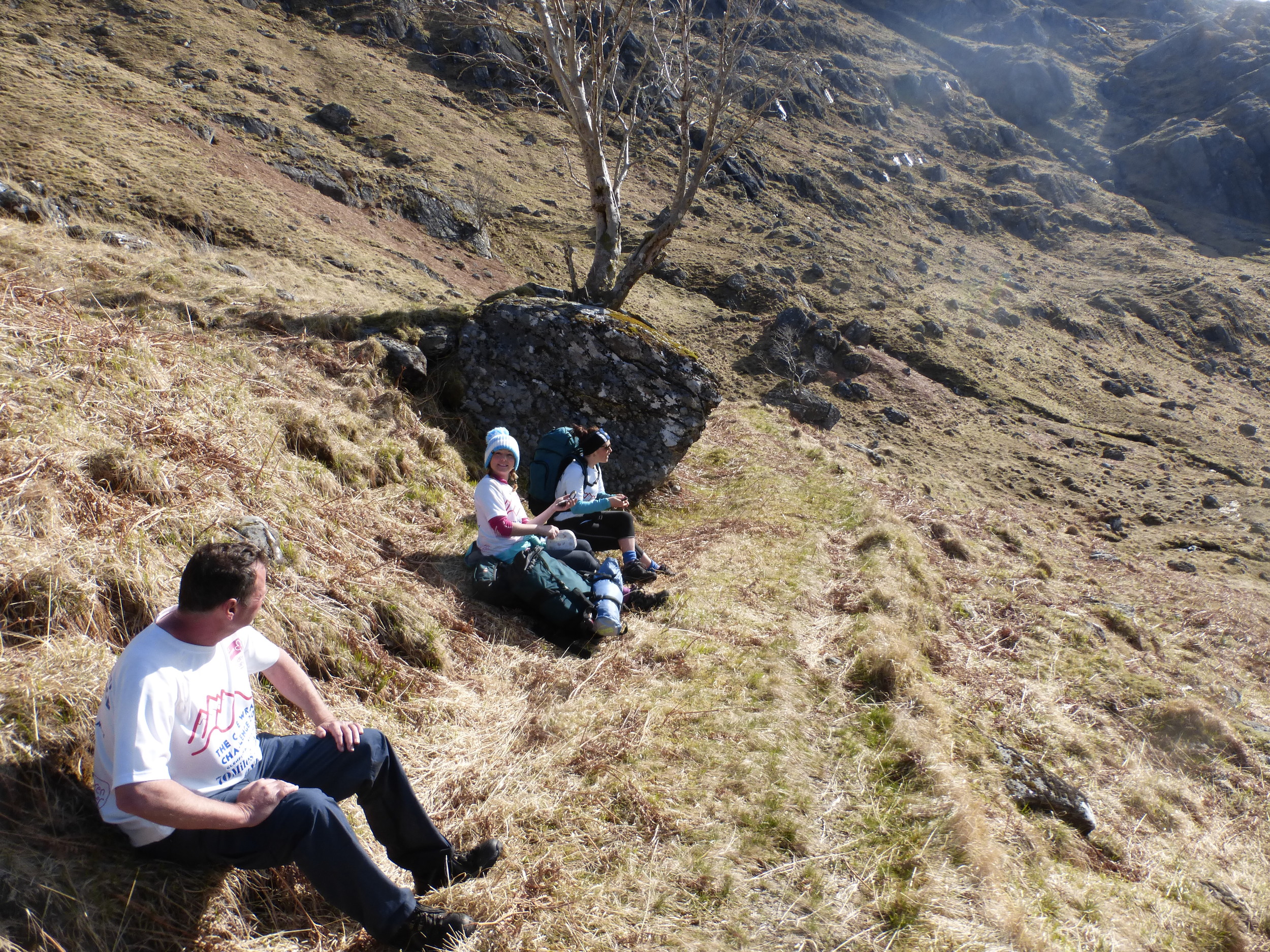
After a good sleep, I was first at to surafce just after 6am.  I was conscious of the need to get up and away as early as possible as we would need all available daylight if we were going to stand any chance of reaching Shiel Bridge before dark.  Ellie soon appeared from the confines of her tent and I soon realised that her sleep wasn't quite as successful as mine.  Having just announced to Alan that I probably had my best ever sleep in a tent, Ellie added, in a flood of tears, that she just had the most miserable night of her life.  Freezing cold, wet and with no sleep whatsoever, she definitely wasn't up for 'high-fiving' the experience. One by one, the team gradually emerged from their own little canvas worlds into what was actually a glorious morning.  At 7am, with the sun hiding behind the mountains, it was bitterly cold, but the mood within the camp was actually very positive and upbeat - if only they knew what was come!!

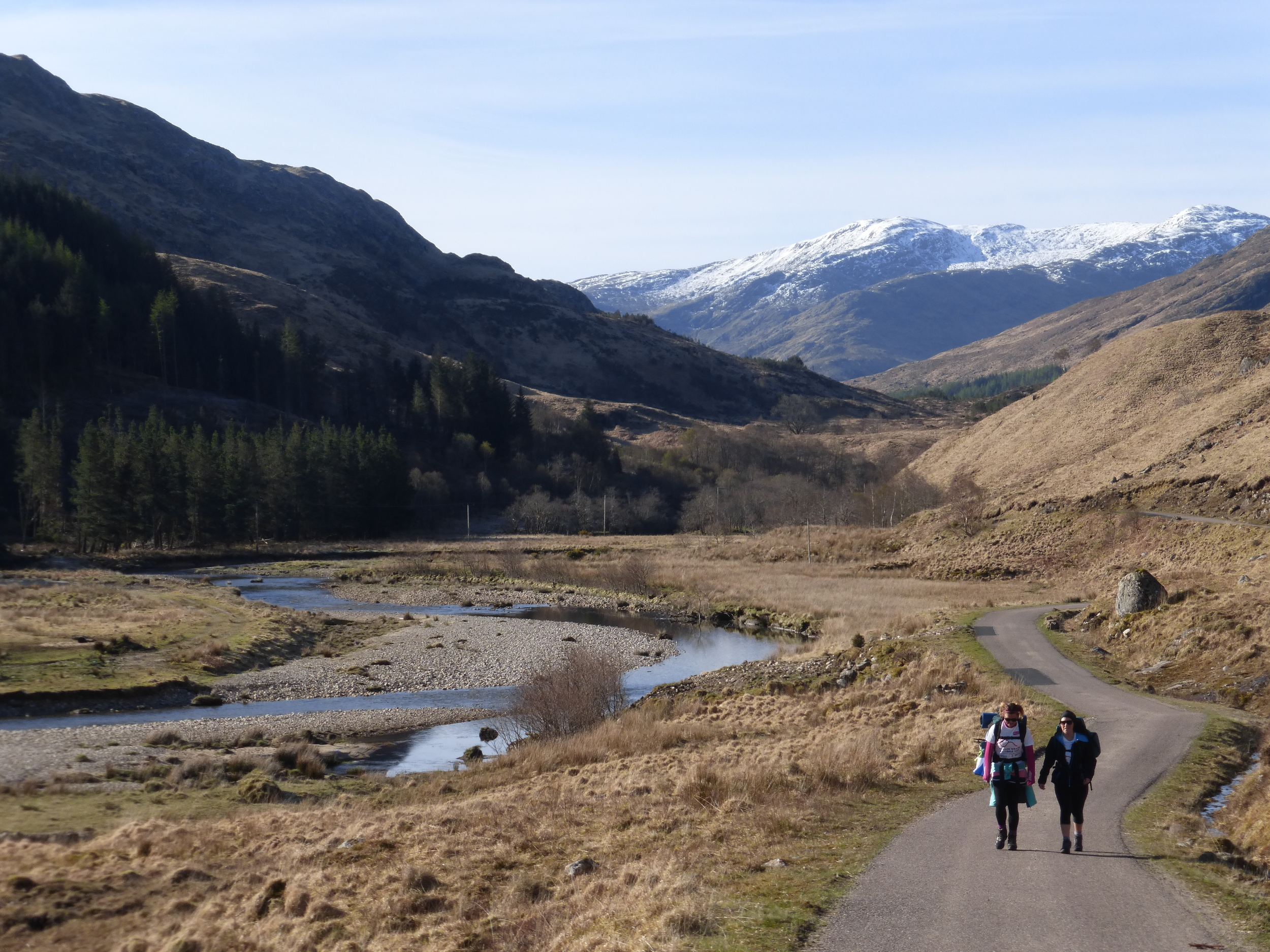
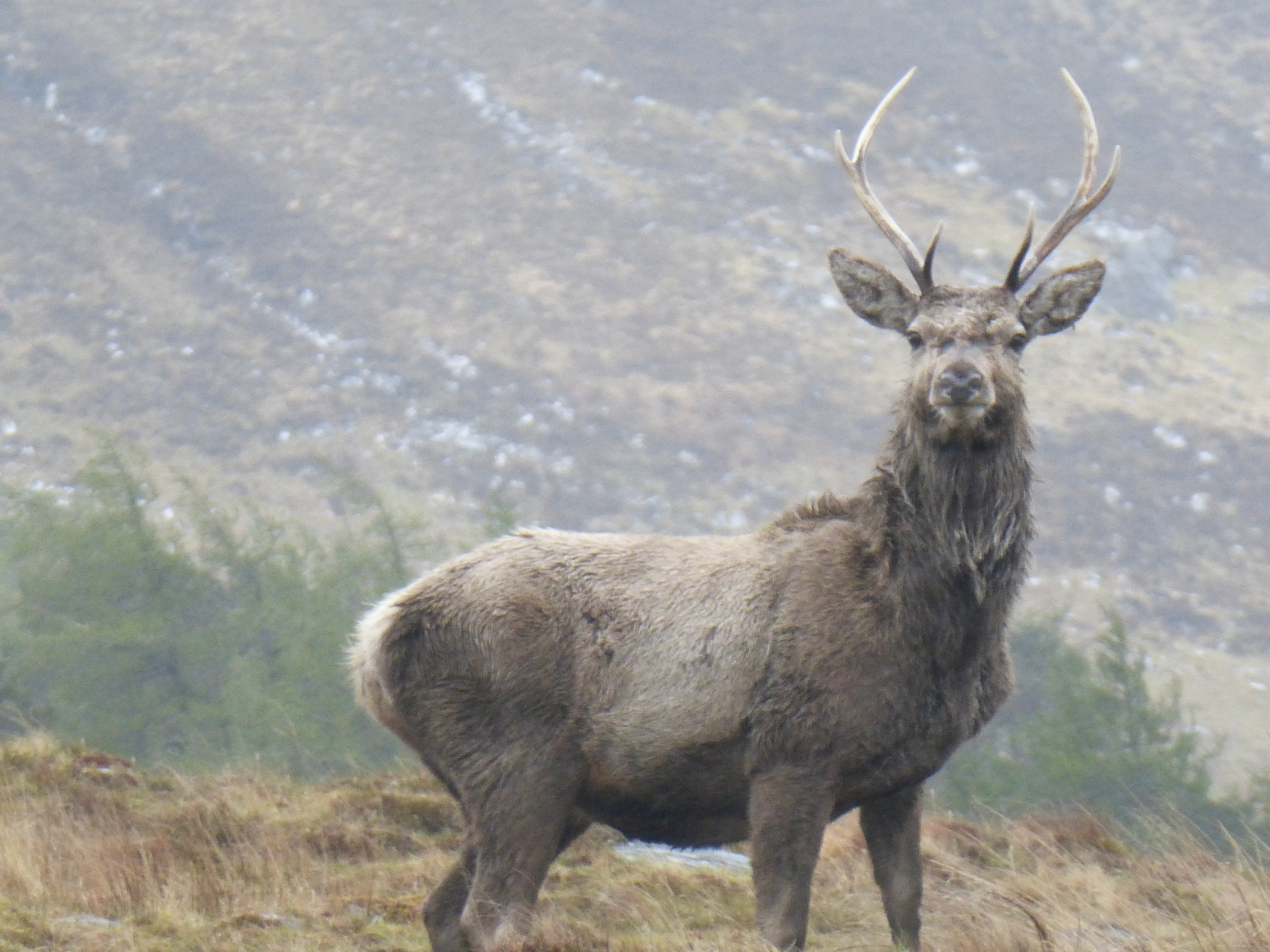
The first section was to follow the River Carnoch upstream into the heart of the Knoydart.  It was a lovely start to the day and a beautiful walk deep into the gorge.  The views of Knoydart were ever more awesome as we turned each corner; the morning sun shimmered on the grass laden mountain slopes, awash with purple heather, little groups of trees and pockets of snow - it was truly stunning.  The rising sun splayed elongated shadows across the rocks and boulders which clung to the hillside, adding that little bit of drama to the landscape.  

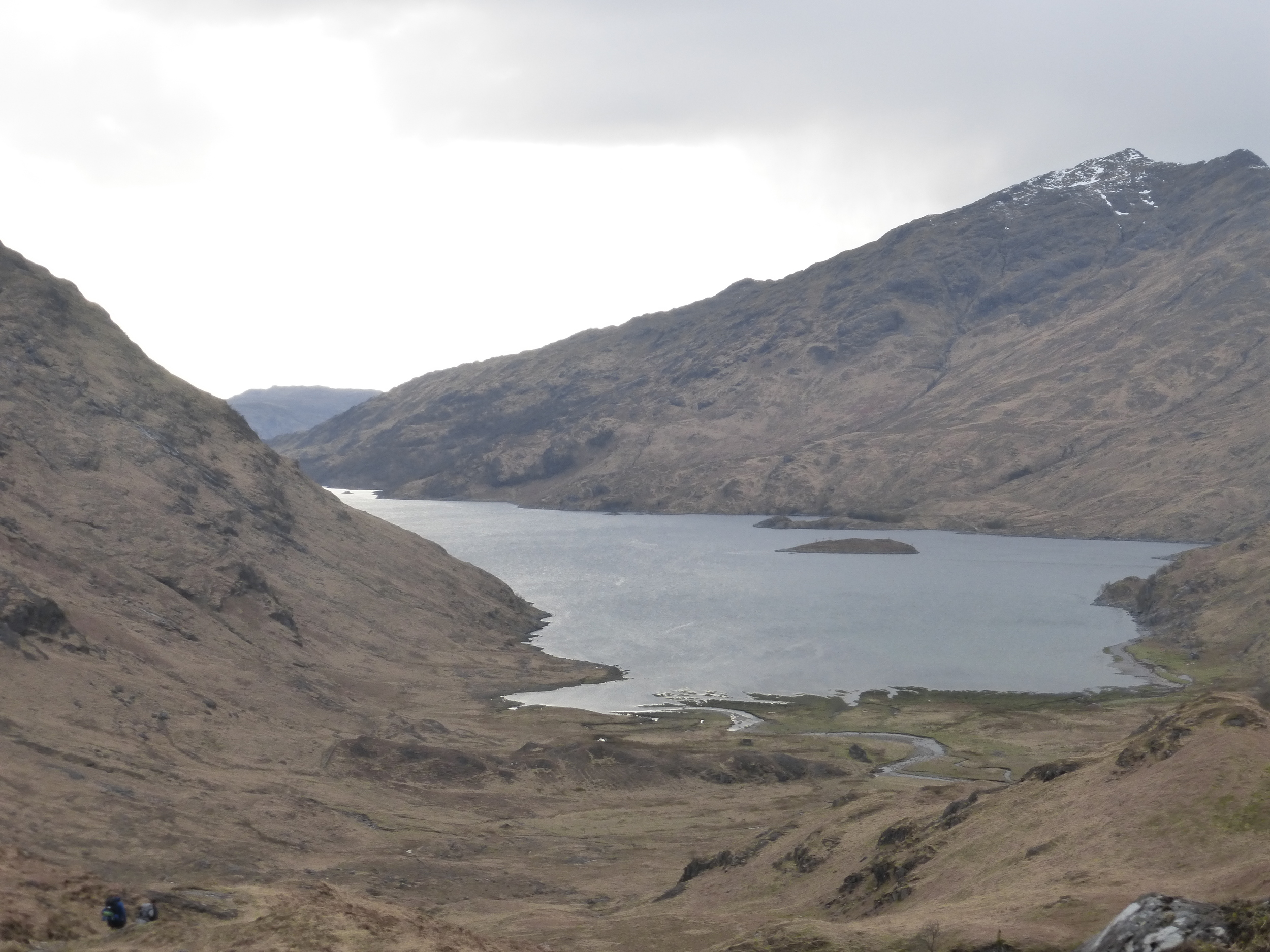
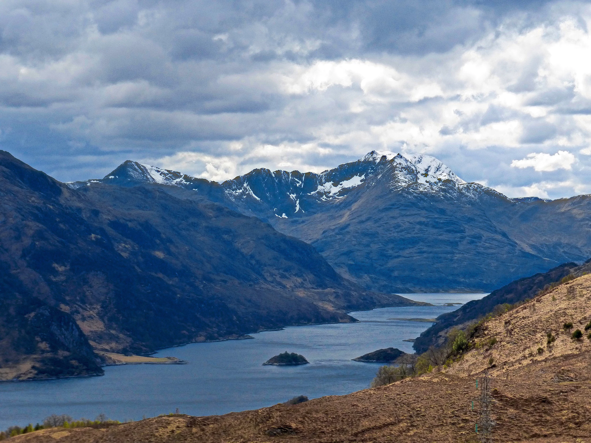
Before long, it was time to leave the riverside and head directly up the hillside to the mountain path which led to Barisdale and Loch Hourn. I recalled from my previous time on the trail that this was a hazardous climb, fraught with the possibiilty of slipping to the bottom with one false move.  Etched in my mind were memories of scrambling up an almost vertical face, clinging for dear life onto little tufts of grass and heather, desperate not to fall back down to the River Carnoch below.  My concerns were allevaited somewhat as the climb, this time, was nowhere near as bad - although it was still a tricky and steep scramble.  A few of the guys made the first attempt while I waited back for the others.  It would be unnecessary waste of energy by storming up the hill; slow and sure was the name of the game and half an hour later we had all made it and reached the path high on the mountain.  The views up here were astonishing - you'll be hard pushed to find anywhere more picturesque in the whole of Scotland.  We were in the middle of Knoydart, the sun was shining, skies were blue and the mountains were spectacular.  This view was my highlight of the three day challenge. 

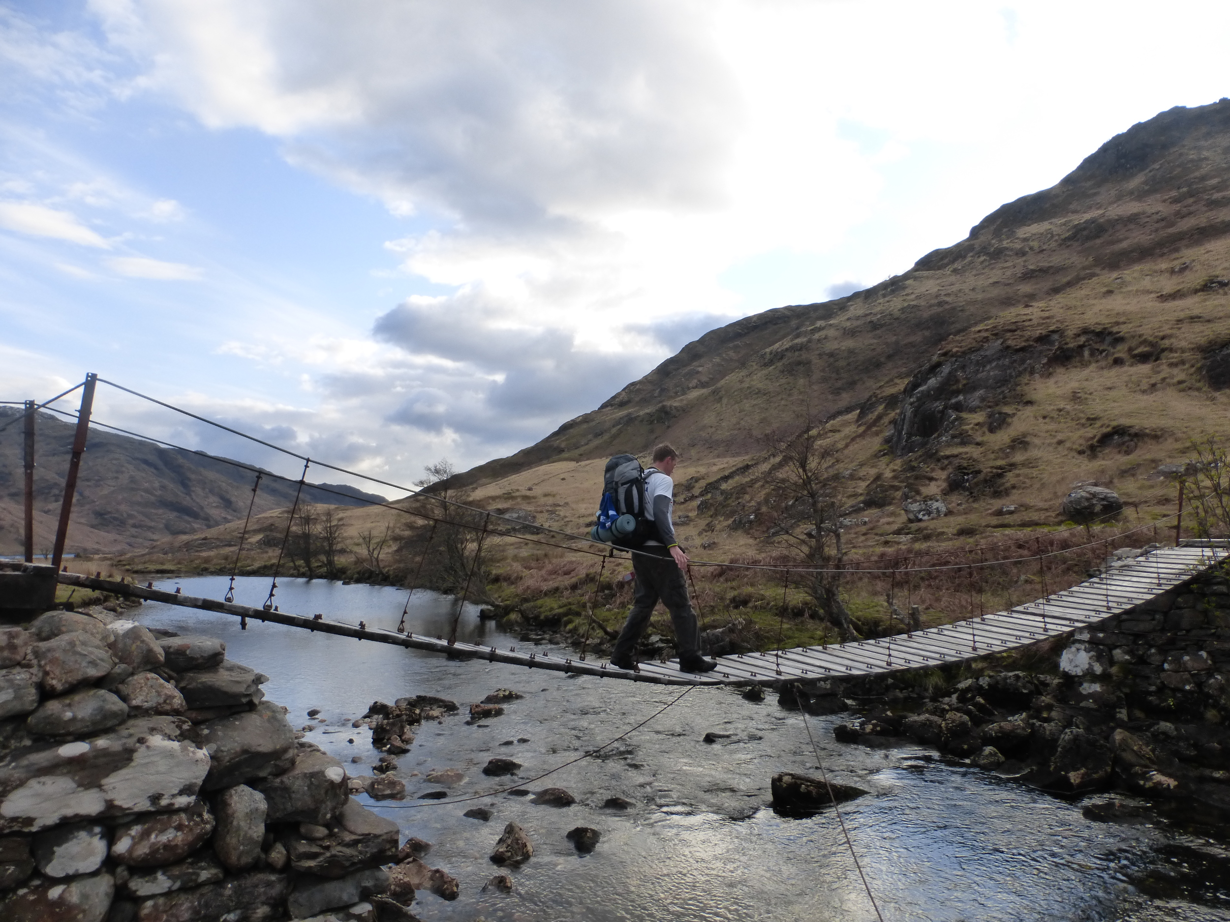
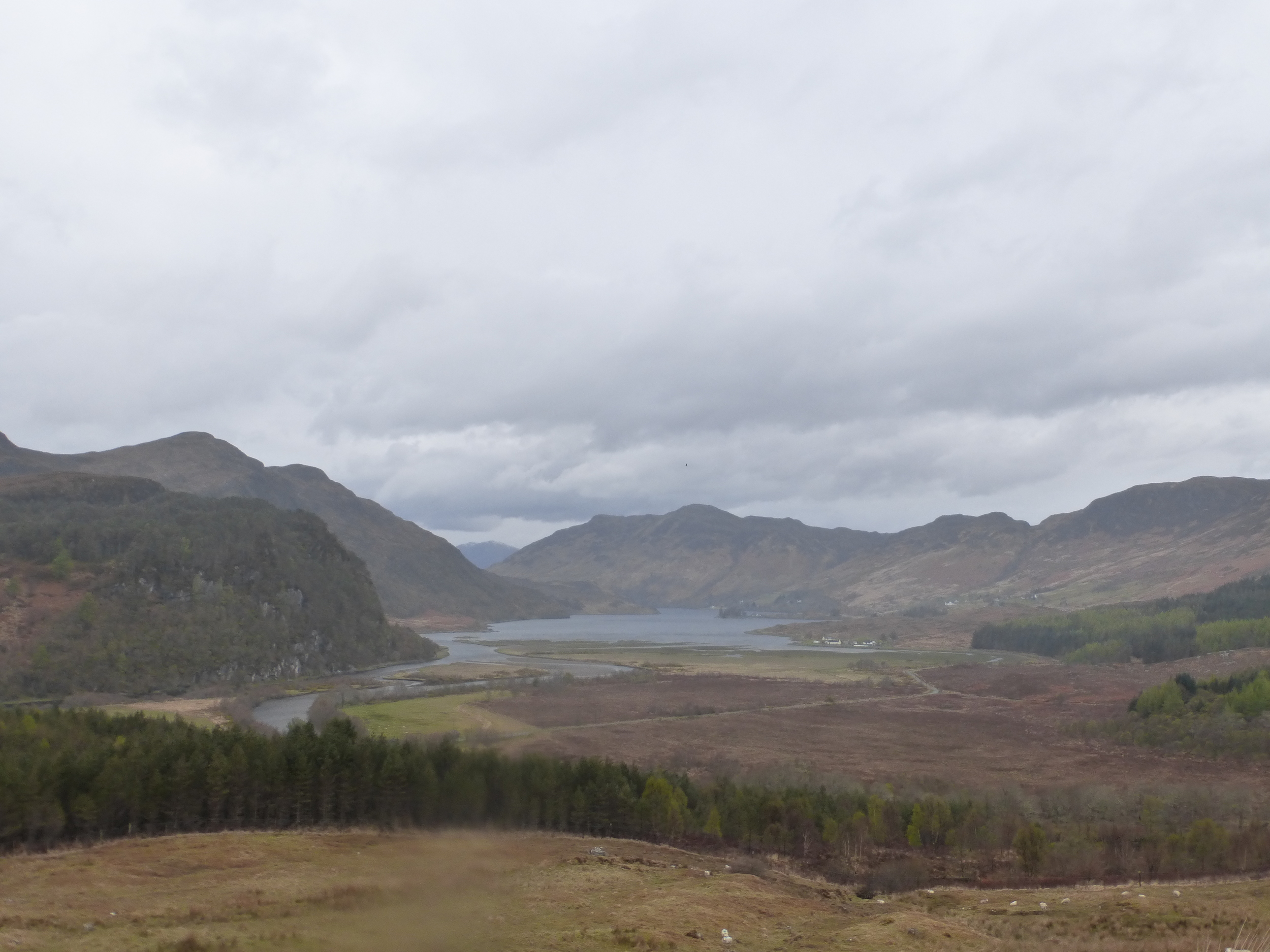
Re-grouped, we continued along the narrow hillside path, climbing gradually to the 500 metre high mountain pass, before leaving behind those wonderful views surrounding Loch Nevis and Loch Quioch.  One stunning view was soon met by another wonderful horizon, this time of Loch Hourn and the distant mountains of Loch Alsh and Skye.  The descent to Barisdale was steady and gradual, following the glen to the shores of Loch Hourn.  The group, by this stage, had separated considerably.  At the bottom the hill, the leaders waited at a wooden bridge for about half an hour for the others to catch up.  I was now having real concerns over our pace as a group - it had taken a lot longer than I thought to complete this section and, at this rate, we would never make Shiel Bridge before dark.  It was time to get serious.  After a discussion with the team, Kenny F, Chris and Ollie decided that they would walk to Kinloch Hourn and make arrangements to for a taxi to take them the rest of the way to Shiel Bridge.  It was a really tough and emotional moment.  The guys desparately wanted to continue with the rest of us, but with a combination of niggling injuries and fatigue, they were completely selfless in allowing the rest of us to continue at a pace which would get us to Shiel Bridge before dark.  We said our goodbyes, shared a few hugs and we were on our way.  Two minutes later and unbeknown to Kenny, Chris & Ollie, Gary decided it would be a good idea to open a can of John Smith's for the walk through Barisdale.  I shudder to think of their reaction if they knew Gaz had opened a beer through their moment of pain (of couse I had to have a sip for medicinal purposes).

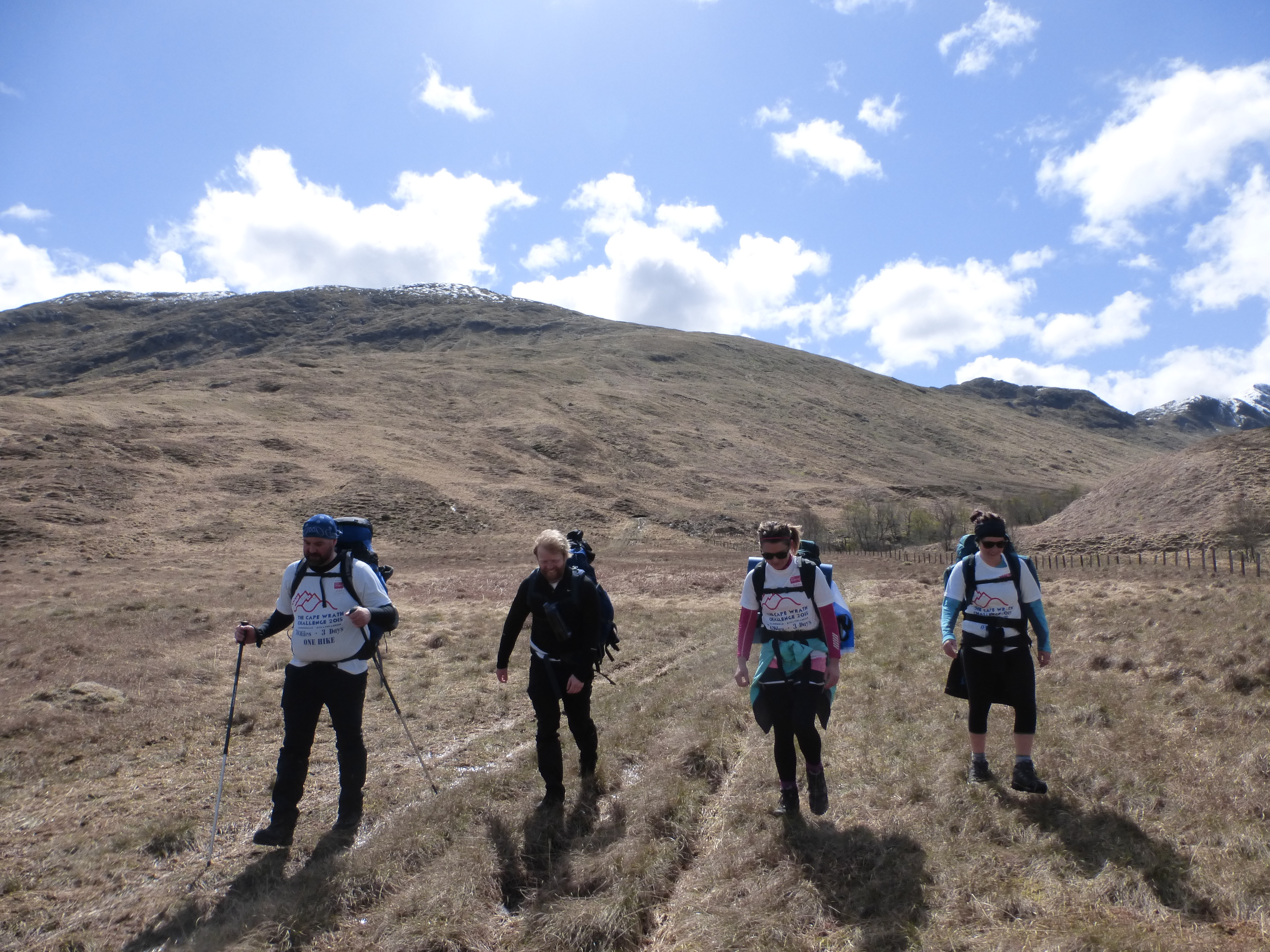
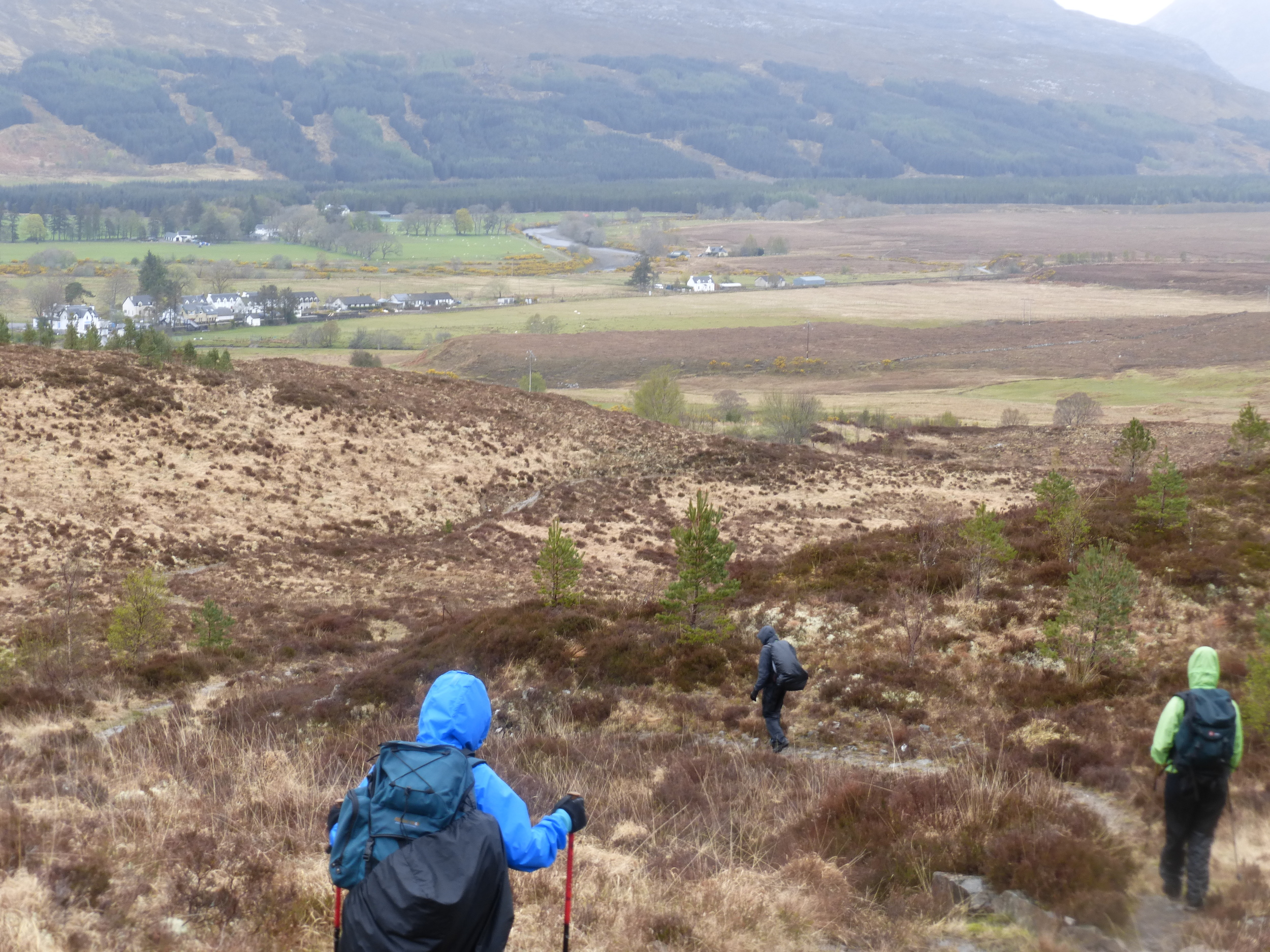
The six mile path along the loch was an enjoyable walk, although unexpectedly tiring with a few steep climbs that you don't really see on the map.  By the time we reached Kinloch Hourn, it was nearly 3pm and the legs were beginning to feel weary - not great considering the toughest leg of the entire challenge was waiting for us around the corner.  We needed a break to recharge the batteries, after which we would have five hours of daylight to climb 700 metres over 9 miles.  This was a mini challenge all in itself and to make matters worse, the weather was beginning to take a turn for the worst - the sun had gone for the day and the wind was really picking up.  Just as we were about to leave, Alan dropped the bombshell that he was stopping here for the day and would wait for the guys behind.  I don't think he was even quite sure why he was stopping, it just felt like the right thing to do at the time.

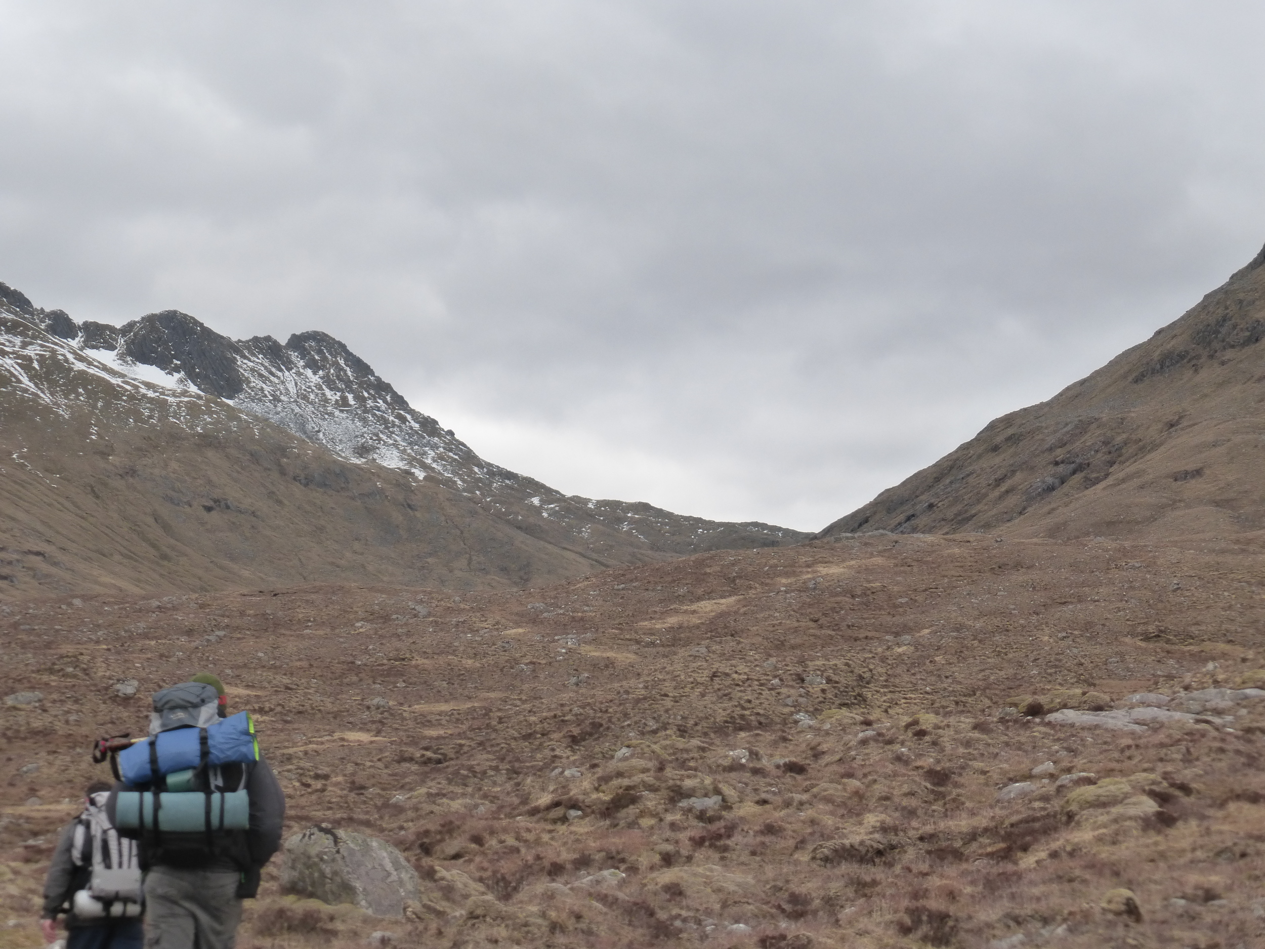
In all honesty, I was really worried as we set off for the trek to Shiel Bridge.  While researching the trail, I was expecting one or two potentially tricky river crossings and a long pathless section up the south side of the bealach to Forcan Ridge, which would take us to our highest point at 700 metres.  There was also the fact that we had left four of the team a few miles back - I had to assume that they would make it safely to Shiel Bridge - somehow!!  I decided there was no choice but to shorten this section ever so slightly by leaving the mountain down to the road a couple of miles before Shiel Bridge rather than take the rough, time consuming path through the glen from Forcan Ridge into Shiel Bridge.  Our back up driver, the ever reliable Steve Turner, who was traveling up from Dundee, was alerted to the slight change of plan - hopefully he got the voice message and would be there to pick us up at the layby on the main road.

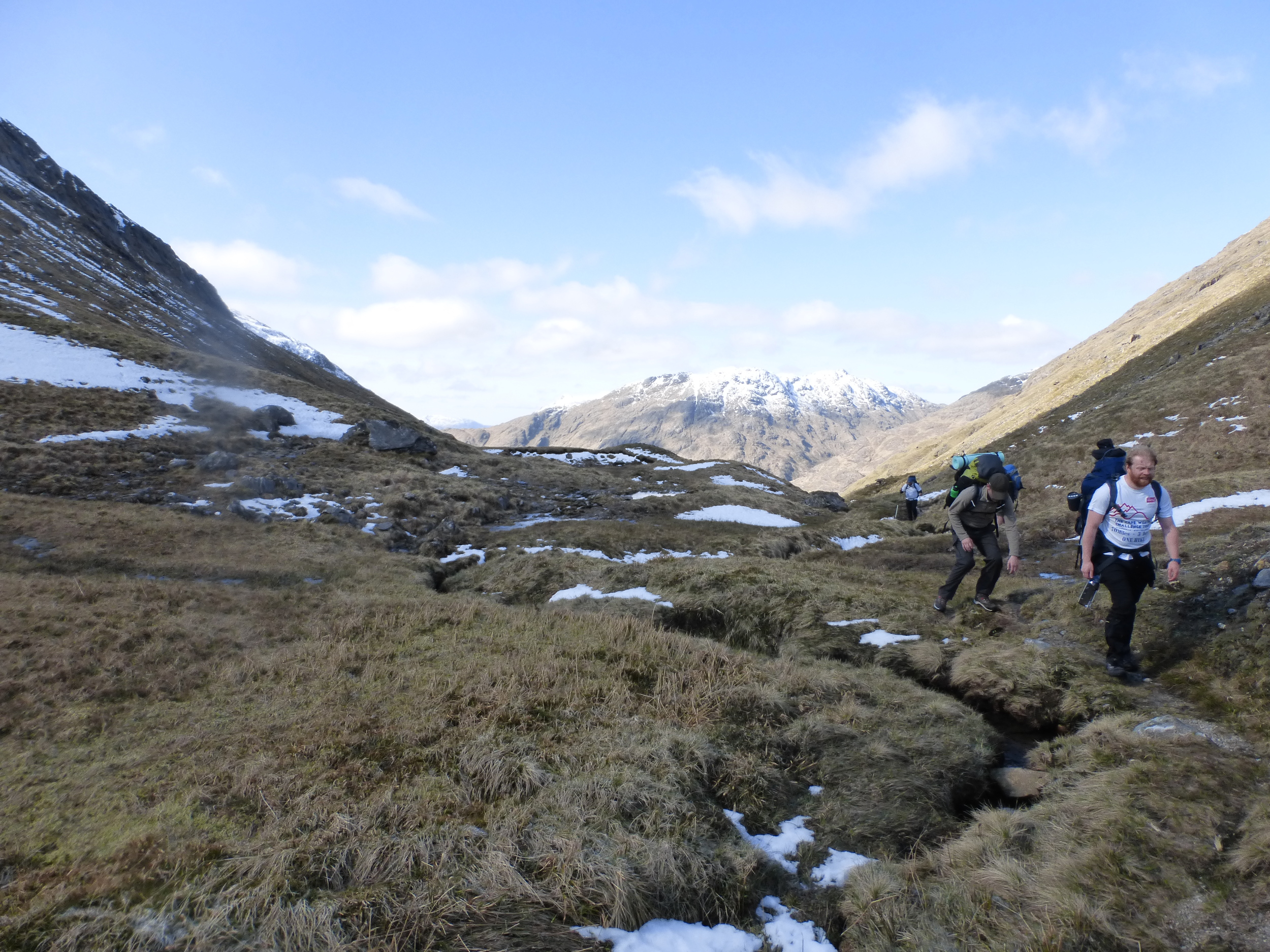
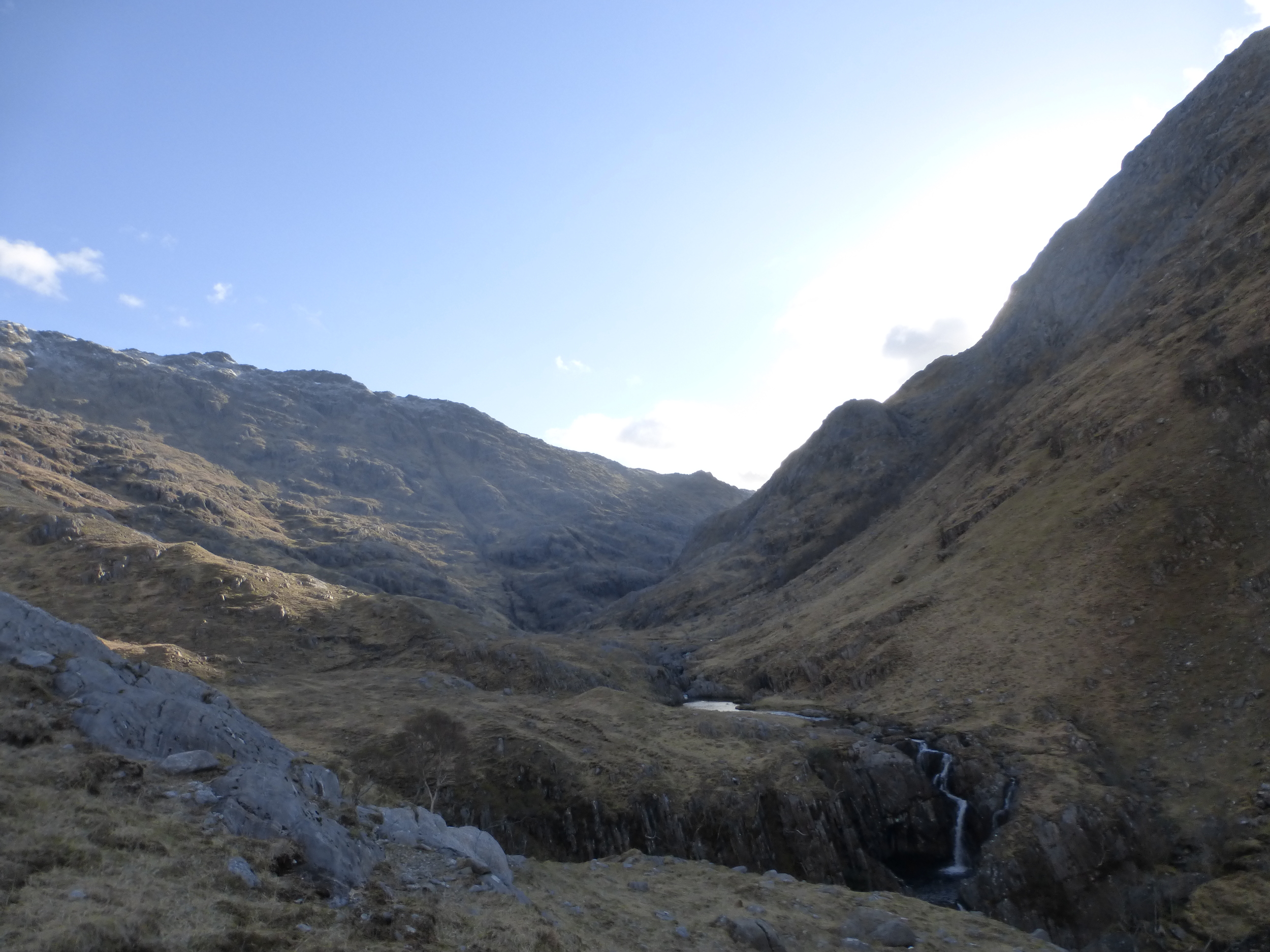
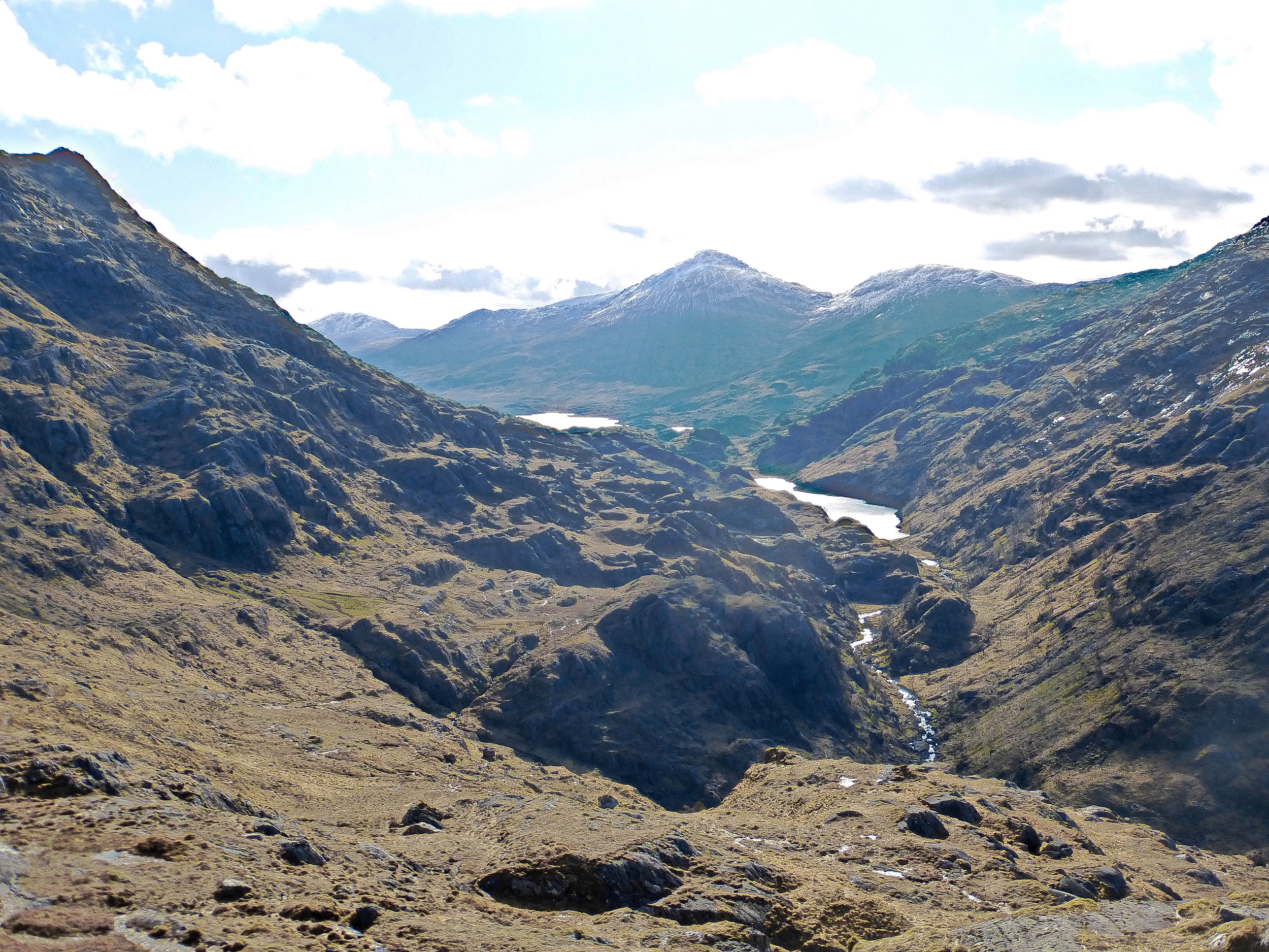
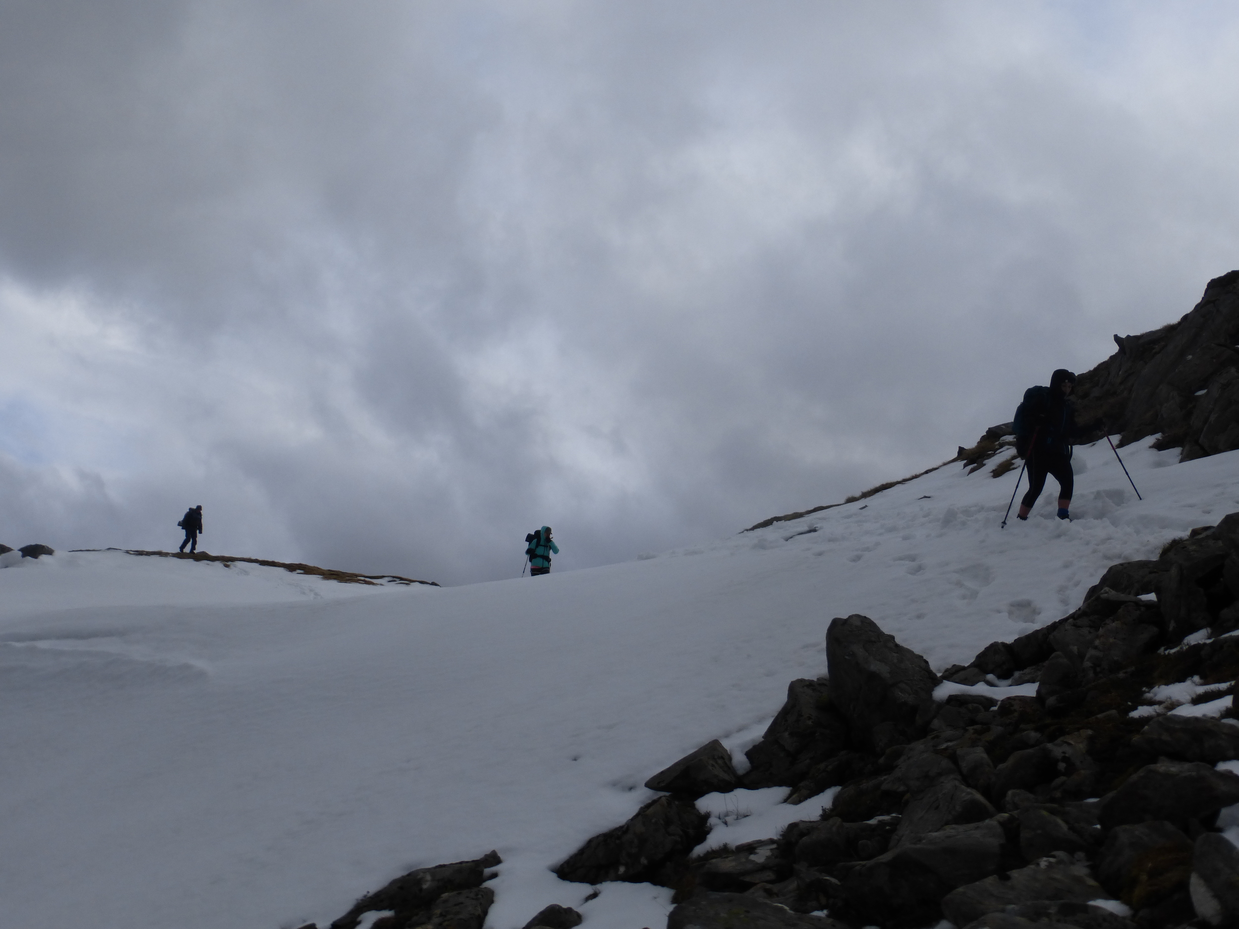
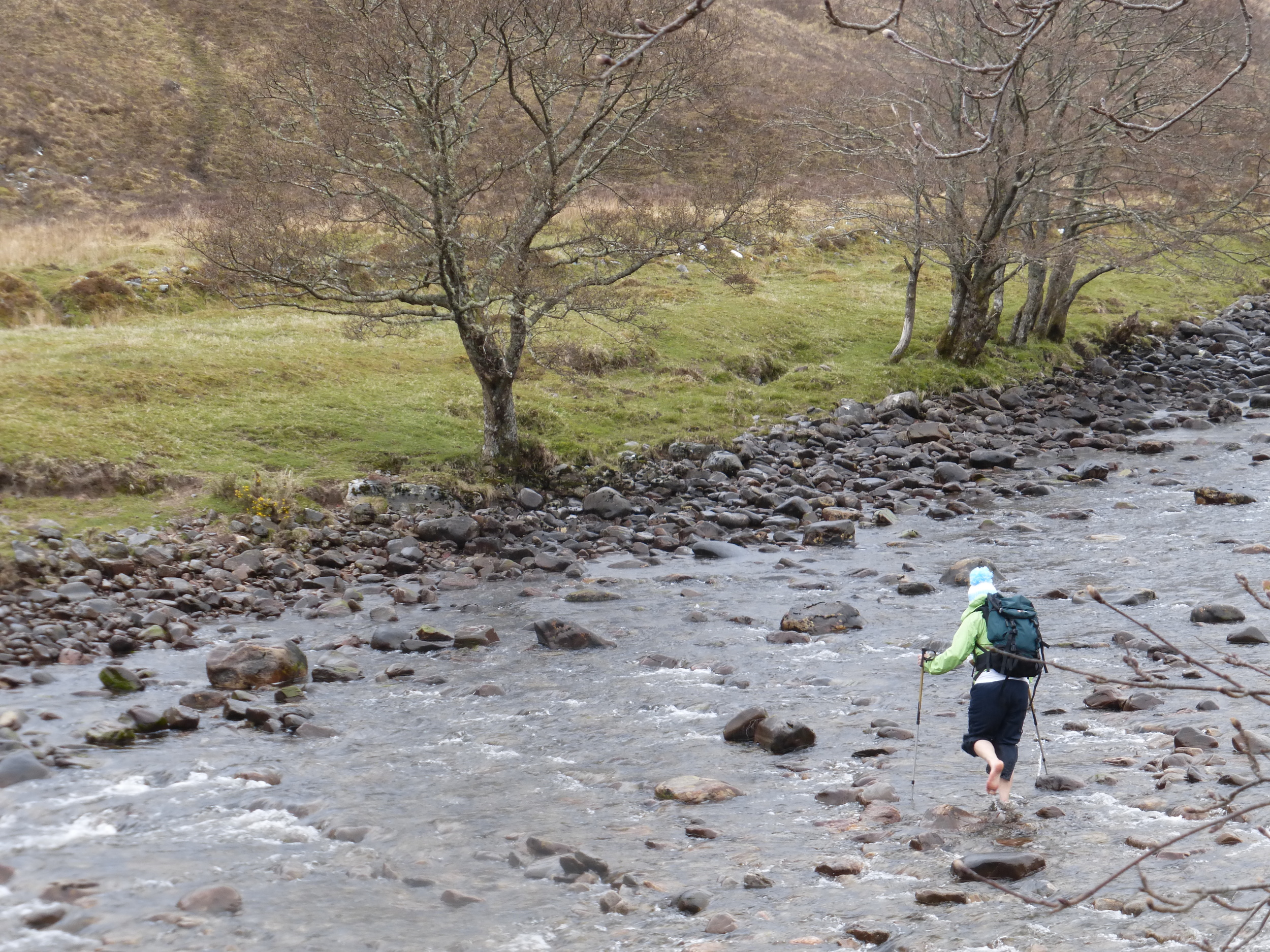
The climb out of Kinloch Hourn was quite severe, which wasn't helped by the makeshift, eyesore of a track recently created to aide the construction of an overhead electrical power line (which apparently plugs Skye into the grid).  Although tough going, we were making good progress becoming more confident of making it to Shiel Bridge by 20:30.  The rivers weren't in spate which made for easy crossings and, at the point where we traversed the south west shoulder of Sgurr Na Sgine's lower slopes, we reached the end of the track, the team was fairly upbeat.  I pointed out the bealach that we were heading to and, although the snow covered peak of The Saddle looked slightly intimidating, the fact we were just going up and over the lowest point of the mountain pass didn't look too bad - oh how these hills can be deceiving!!  The nextninety minutes were probably some of the most exhausting we had ever experienced.  The slopes was becoming steeper with every step, the ground underfoot was becoming increasingly treacherous and the top of the pass seemed completely unreachable.  As we edged closer to the head of the bealach, I could feel the wind getting stronger and the chill factor was much more intense. We had reached the snow level, sitting at around 550 metres, although thankfully it wasn't affecting our climb.  I led from the front, trying to find the safest way up the hill.  A number of mini gorges and fissures in the rock were making the route that much more difficult.  There was a great deal of zig zagging across little streams and between boulders, where we would pause for a drink and a few Wine Gums before setting off again.  We could hardly go more than ten metres before having to take a break - it was so exhausting.  After what seemed like a lifetime, I reached top of the bealach first.  I didn't really know what to expect up there but the extremity of wind and the sheer volume of snow made it very unnerving.  The wind was storm force by now, as it funneled between the towering Munros on either side and we felt extremely vulnerable.   The guidebook points out a row of stones which mark the start of a path along the Forcan Ridge and ultimately off the mountain - but I couldn't see it anywhere.  Snow was now the dominant factor and cause for concern, making it very difficult to navigate and I could tell that some of the little pockets were deep and likely to dislodge at any time.  We had to avoid walking across any snow in case we fell right through it, while also leaning into the wind in order to stay upright.  After a while, my eyes adjusted to the conditions and could just about make out the wall we were looking for.  The only way to reach it was to climb another fifty metres around the edge of the snowline and descend sharply.  It was a treacherous little section and, where I felt ok (even though I fell waist deep in a pool of icy water), I still felt responsible for the safey of five other people behind me; and that reality was beginning to prey on my mind.  We'd already left four people behind - I shudder to think how we would have fared as a group if all ten of us had decided to tackle this section.  Sometimes, when you're so exhausted, both mentally and physically, your emotions get the better of you and, as we were making the slow descent off the hill, I was reflecting on the day and felt the need to phone home to speak to Jenny and the kids.  When she answered, all I could say was, 'hello' before I started bubbling away, explaining how hard the challenge was and that I had put the team through far too much.

The wind was still fierce as we reached lower altitude, in fact, it was getting stronger.  I was now beginnning to think we would be in for a rough night if it was going to keep up like this.  For the last few hours, the magnitude of this challenge really started to sink in.  It had been a hugely tough day - more than I'd ever dare to tackle on a normal walking excursion.  But, it was for charity and we had to make it difficult if we were to raise money for CLIC Sargent.  We could see the road below from a long way up - which never helps.  It took an age to get off the mountain, although remarkably we had reached the finish by my estimated time of 20:30 (ish), it was just a pity we had to get a lift for the final mile or so to the campsite - which leads to another story all in itself.........

Steve had received our message and was on hand to drive us along the road to camp - excellent.  On our way along the road, I heard a bang but thought nothing more of it as the car seemed to be moving along ok, I thought nothing more of it.  Coincidentally, the rest of the team arrived in a taxi from Kinloch Hourn at almost exactly the same time. I was very happy and so relieved to see them. They were in good spirits and made the walk to Kinloch Hourn ok.  Unfortunately, all but Alan had decided their hiking exploits were over, for this challenge anyway.  As for the camping, the efforts of the last few hours had really taken it's toll on some of the team, to the point where I wondered if anyone would be able to walk the following day.  Whether it was a twist of fate or simply pure determination to find anywhere to sleep other than a tent; Donna, Ellie, Kenny, Alan & Steve found a static caravan to bunk in for the night - to them it was heaven and maybe what was needed to recharge the batteries for day three and the final push into Strathcarron.  As they left for the caravan in Steve's car, we noticed he had a puncture - we couldn't believe it - even our back up car was knackered!!

The path upstream along the River Carnoch offered some beautiful views.  Ahead lies the climb where we scramble up the hill to the path which leads to Barisdale

The path upstream along the River Carnoch offered some beautiful views.  Ahead lies the climb where we scramble up the hill to the path which leads to Barisdale

Simply stunning views across to Loch Cuaich

Simply stunning views across to Loch Cuaich

Niall, Donna & Ellie take a well earned rest after the climb from the River Carnoch

Niall, Donna & Ellie take a well earned rest after the climb from the River Carnoch

A look north down to Loch Hourn from Gleann Unndalain

A look north down to Loch Hourn from Gleann Unndalain

Barisdale really is a beautiful location only accessible by boat and hardy hikers

Barisdale really is a beautiful location only accessible by boat and hardy hikers

Gary enjoying the view alongside Loch Hourn

Gary enjoying the view alongside Loch Hourn

A view of Loch Hourn looking South West.  The Cape Wrath Trail follows the banks on the far side

A view of Loch Hourn looking South West.  The Cape Wrath Trail follows the banks on the far side

The pathless climb to the bealach between The Saddle and Sgurr Na Sgine doesn't look too bad - until you actual climb it.

The pathless climb to the bealach between The Saddle and Sgurr Na Sgine doesn't look too bad - until you actual climb it.

Things were a bit treacherous at Forcan Ridge until we found the path

Things were a bit treacherous at Forcan Ridge until we found the path

Day 3 - Shiel Bridge to Strathcarron, 21.0 miles 1,163 metres climb

(actual distance hiked - 13.7 miles, 1,119 metres climb)

That night was wet and wild to say the least and I was surprised that our tents were still intact by morning.  Other campers on site were not so fortunate; one couple were busy trying to rescue their outer sheet from a nearby field, while another family's tent collapsed on them during the night.  The frame on my new tent had been reshaped by the gale force winds which pounded the campsite throughout the night.  What was once a strong and rigid pole now resembled a wonky boomerang.  I couldn't believe the wind had done this to the frame without managing to snap it.  The windy conditions hadn't let up by morning and we had to decide on our plan of action.  Could we make the full twenty one miles without being blown off our feet and off a cliff face?  Steve's puncture limited our choices.  It would be at least 08:30 before the car could be fixed - and we had originally planned to leave at 7am for a three mile road section through Shiel Bridge to the start of the next stage.  Without this, we faced the prospect of this now being a twenty four mile day - simply not an option in these foul conditions. 

We decided that it was too risky to attempt the full distance as we just didn't know how bad the weather would be at the highest point at 500 metres.  Any snow, coupled with these winds, would have been a show stopper.  The guys who stopped at Kinloch Hourn on day two had arranged for Steve to drive them back to Fort William, where they would make the onward journey home.  We were now a team of seven, which I was delighted with given the condition of everyone after the exertions of the previous day.  We managed to find a local taxi who agreed to take us from Shiel Bridge to Killilan, while Steve took the others to FW.  It was a sore one to take as it meant cutting short the original seventy mile Challenge, but there really was no choice if we wanted reach Strathcarron in one piece and before dark.  On paper, the final 13.7 mile leg didn't seem too bad.  The terrain here was different to Knoydart - less intimidating, not as remote with more of a rolling landscape.

Despite the wind and rain, we set off in high spirits.  The going underfoot good as we followed a well established stalkers track for the first couple miles.  The first real challenge of the day was negotiating the River Ling.  There was no bridge so it was a case of removing the socks and shoes and wading across the freezing cold waters.  The river was around twenty metres or so wide, which was a fair old crossing.  I had a pair of lovely bright white Crocs which were perfect for the occasion.  Fair play to Ellie for going across in her bare feet - standing on so many jaggy rocks and stones couldn't have been pleasant.

The rain was becoming progressively heavier and more persistant and, once we found the next stalkers track up the hillside to Loch an Iasaich, the conditions were miserable.  It was simply a case of hiding inside your waterproof, getting the head down and marching on as best we could.  As we exited the forest and started the next climb, this time passing Loch an Droighinn and Loch na Caillich, the rain had started to ease and we were at least able to chat amongst ourselves again.  The track ahead was clear and it appeared for a while that it may be like this all the way into Strathcarron.  By now, I was having some real discomfort in my left foot.  My feet (and Gary's for that matter) took a real pounding at the previous weeks Highlander Mountain Marathon, especially where we had to run across a never ending boulder field near Inchnadamph in Sutherland.  The few days inbetween the two events just weren't enough for my foot to recover and it was quite painful by lunchtime.  I was desperate to get off the stalkers path and onto the hillside, where the softer impact of the sodden heather and long grass would have provided some welcome respite from this hard 4x4 track.  The other guys didn't seem to mind, emphasised by the fact that they were motoring well ahead.  What they seemed to forget, however, was that I had the map and was aware of a point where we had to leave the track onto the hillside and follow an old ruined fence which would lead us over the crest of the hill and to the hotel.  By the time I had worked out exactly where this was, Niall and Kenny had walked so far on that they were out of ear shot.  Five minutes later, after a bit of running and shouting down the line, we were all together again.  The map suggested there was a path to follow but in reality, there was nothing but the distant bealach, which would be our final climb of the challenge.  The ascent was much less daunting than it looked and we made the climb in good time, albeit through thick heather and boggy marshland.  Close to the top of the hill, the path eventually presented itself and it was from here I could relax in the knowledge that all we had to do now was follow this off the hill and into Strathcarron.  My navigational responsibilities were over and it was a great sense of relief to have led the team from Glenfinnan across all sorts of highland terrain without getting lost.

After that final climb, I made the mistake of saying, '...it won't be long now', thinking Strathcarron was just around the corner.  It seemed like a never ending descent and the team, particularly the girls, were getting agitated.  The rain was back on and, for the first time, I was feeling cold.  Although my waterproof jacket was holding up well against the elements, my gloves were soaked through as well as the cosy Thinsulate's.  We could now see the village in the distance and light was at the end of the tunnel.  Eventually, at about 3:30pm, we dragged our soaking, bedraggled and completely exhausted souls across the finish line and into the indescribable comforts of the hotel.  No fanfare or hoards of people there to welcome us - but that didn't matter.  We had completed the Cape Wrath Challenge and it felt amazing.  Yes there was more than a fair share of blood, sweat, tears and cursing along way but it was a truly wonderful adventure and an unforgetable experience.  New friendships were forged and existing ones strengthened - we had a fantastic group of guys and, for what they had to endure over the three days, there was never a word of complaint from anyone (not out loud anyway) and I thoroughly respect their determination to overcome every challenge which came their way.

The Cape Wrath Challenge was a success on so many levels; we'd made it from Glenfinnan to Strathcarron in one piece and many personal goals were achieved.  One of the main goals from the challenge was to raise money for charity and, as successfull as this was (nearly £3,000 for CLIC Sargent), the biggest success for me was giving ordinary people the opportunity leave the rat race of daily life to experieince Scotland at it's finest, while conquering Britains toughest trail and seeing the joy in their faces when we reached Strathcarron.  We live in a truly beautiful country and this experience will last with me and the team for many years to come.

Total Distance hiked: 60.2 miles

Total Climb: 4,357 metres

Just after leaving Killilan we were met by a herd of deer, who didn't seem bothered about our presence in the slightest

Just after leaving Killilan we were met by a herd of deer, who didn't seem bothered about our presence in the slightest

Ellie braves the freezing cold water as she crosses the River Ling

Ellie braves the freezing cold water as she crosses the River Ling

One of the few good views on Day 3.  This is the head of Loch Long near to Killilan

One of the few good views on Day 3.  This is the head of Loch Long near to Killilan

Nearly there.  The team edges closer to Strathcarron in the distance

Nearly there.  The team edges closer to Strathcarron in the distance

We made it and still smiling (Niall's taking the picture)

We made it and still smiling (Niall's taking the picture)


The Rob Roy Way - Pitlochry to Aberfeldy - 9.10 miles

Perthshire is such a beautiful part of Scotland and I regularly take a break from the hustle bustle of the Central Belt for a weekend of peace, quiet and fresh air.  This time, my wife and I, after organising babysitters for the weekend, took ourselves to Braes Lodge, 15 minutes north of Aberfeldy, tucked away in the shadow of the mountain of Schiehallion.  This was a stunning retreat, with views to die for.

There are a multitude of fantastic walks in the area; ranging from gentle strolls alongside The River Tay and the 'Big Trees' of The Hermitage, to dramatic gorge walks through the Birks of Aberfeldy and strenuous climbs up some of Scotland's most dramatic mountains.

This time, we opted for the relative ease of the Rob Roy Way, walking from the official end point of the trail in Pitlochry (or start, depending on which way you are walking from), back to Aberfeldy - a lovely 9 mile stretch through woodland, hillside and finally along the River Tay.

Starting at the War Memorial near Pitlochry town centre, we made our way towards the damn and fish ladder before climbing away from the town, carefully crossing the busy A9 road and heading into the tree covered hillside.  Upon reaching the A9, we crossed the road and followed a farm track, passed the farm itself, soon reaching the tree line.  At this point the path climbed steeply through the trees along what was now a forestry track.  A few minuted later, I was glad to see a Rob Roy Way signpost which directed us away from the wide vehicle track onto a more natural, narrow footpath which followed a lovely tumbling burn upstream.  We were still climbing at this point, but with the path winding through a combination of newly planted evergreens, whispy Brooms and age old Birch Trees, it was a delightful section of the walk.  

As we reached the top of the hill, the path rejoined the forestry track and continued through the forest.  Approximately 2.5 miles from the start, the forest opened out provide excellent views of the surrounding mountains, where we also spotted an ancient Stone Circle - the perfect spot to stop for some lunch.  We were soon on our way, heading back into the woods, where we continued along the track to the edge of the forest.  After climbing over a tall stile, we were out on the open hillside as we descended gradually towards Grandtully.  The walk down towards The Tay was completely different to the hill above Pitlochry, with gorse and heather much more prominent now.  The path itself was a winding, narrow footpath which eventually followed the course of the Tullypowrie Burn as it cascaded towards the Tay.  As we descended off the hill, the path ran alongside a fantastic dry stone dyke, meticulously built many years ago and; although clearly weathered, covered in spongy green moss and somewhat crumbly in places, there was an air of beauty surrounding this early age construction (as strange as that may sound).

Soon after, we reached Strathtay Golf Course and stood an awe at the grandeur of the stunning buildings which scatter the area around the villages of Grandtully and Strathtay.  After a well deserved pint at the warm and cosy 'The Inn on the Tay', we started our riverside section of the walk.  This was never going to be as interesting as the walk from Pitlochry to Grandtully, however, it allowed us a more gentle stroll along the banks of The River Tay, even holding hands on the odd occasion (it is sometimes possible to be romantic while wearing khaki combat trousers and mud covered walking boots).  For the first 1.5 - 2 miles, the track follows an old disused railway, and is very linear in its direction.  After a while, the path becomes much more natural in form, following the contours of the river, hugging the banks for most of the remainder of the walk into Aberfeldy.  We saw lots of evidence of Beaver activity, whether it be attempted damns (not a good idea on the Tay) or gnawed on trees, which looked more like huge pencils with their newly made pointed tips.

The last half mile of the walk into Aberfeldy town centre, from the Dewars Distillery, is along the main road.  This is no great disaster as the knowledge that your not too far from a bite to eat and a cheeky draught ale is always a welcome comfort.

We were in no rush from the outset, starting at 12:30 and finishing at 17:00, which included a 20 minuted break for lunch and another half hour at The Inn at Grandtully.  We had an extremely enjoyable March afternoon walk, with this stage of the route very typical of the terrain and landscape encountered throughout the Rob Rob Way.  The route is waymarked throughout, although car must always be taken when navigating the paths and tracks across the remote hills and forests.


Is it faster to run or cycle the West Highland Way?

Walk Across Scotland recently organised and took part in a charity run along the West Highland Way, where we were also lucky enough to be joined by 4 cyclists who thought they would partake in the fun.

There were a number of questions to be answered before the event was organised, such as;

How many days should it take to run or cycle the west highland way?

Should we go north to south or south to north?

Can the West Highland Way be cycled?

Can baggage transfers be arranged?

Is it easier to run or cycle the West Highland Way?  Which would be quicker?

It was decided to complete the route in three days and from north to south:

Day 1 - 34 miles (Fort William to Inveroran Hotel), Day 2 - 28 miles (Inveroran to Inversnaid Bunkhouse), Day 3 - 34 miles (Invernsaid to Milngavie).

I am in no way a cyclist and, even though the perception was that it would be easier and take less time to cycle the route, I was more than happy to run the WHW in our small group of 7 guys. Having read a number of blogs and reviews of people of have cycled the WHW in the past, it became clear that cycling was a mighty prospect which should not be underestimated, particularly along the rocky sections of Loch Lomond and the gruelling climb up Conic Hill at Balmaha.

The WHW is obviously well know to us at Walk Across Scotland, at least from a walkers perspective, therefore, I had no misconceptions over doing it on foot - even though I had never attempted the full route in less than five days.  An average run/jog of four marathons is three days is a tough challenge for anyone, especially across rugged and mountainous terrain.

The challenge took place over the Easter weekend (18th - 20th April) and it ended up being an overwhelming success, which was helped by stunning weather from start to finish.  The cyclists had a truly gruelling experience, although they all absolutely loved the entire experience and would not change it for the world.  As for the runners - it was fabulous beyond words and easily the most enjoyable run I have ever done.  The cyclists were behind from the moment we entered the Glen Nevis Forest.  There are a number of hill climbs and rocky paths on the West Highland Way which call for bikes to be carried or pushed, which takes up a great deal of time.  As the runners did not have to worry about carrying awkward loads, they were able to disappear in the distance.  At least that meant the cyclists always had a couple of pints on tap at the end of each day.

The team ended up raising nearly £8,000 for Cancer Research UK (the total is still rising).  The entire event was a roaring success and WAS look forward to helping organise any future fund raising events on the WHW or any other walking/cycling route across Scotland.


The Cross Borders Drove Road

Walking holidays in Scotland tend to take in Highland routes such as the West Highland Way, The Great Glen Way and The Rob Roy Way.  As wonderful as these trails are, our aim is to diversify the areas where walkers would typically embark on a long distance walk.

The Cross Borders Drove Road has recently been recognised as one of 'Scotland's Great Trails', a compilation of the country's most outstanding, way marked long distance walks.  There are currently 26 official Great Trails.

Most people would argue that the Highlands represent the most scenic and challenging landscapes in Scotland and, where that may be true, the Borders region offers it's own uniquely beautiful and historic qualities, which should not be ignored.  In fact, more than ten of the Great Scottish Trails can be found in the south of the country.  

Edinburgh is a huge attraction for tourists and local day trippers, therefore, why not offer a long distance trail which leads into Scotland's capital city.  Starting in Hawick, the Cross Borders Drove Road makes it's way north, climbs up and over the Pentland Hills, and heads into the central belt regions of Edinburgh and West Lothian.  The official finish point of the trail is Little Vantage/Harperrig (on the Edinburgh/West Lothian border), however, in order to provide an end point which provides options for public transport, accommodation and other amenities, walkers have the option to extend the walk further north/north west into West Lothian or east/north east into Edinburgh.

The WAS version of this trail will be between 60 and 70 miles, taking 3 - 4 days to complete.  Accommodation will be available in Hawick, Innerleithen, West Linton, Kirknewton and Edinburgh.  Baggage transfers will also be on available for walkers who do not want to carry heavy bags each day.  

We anticipate that the Cross Borders Drove Road holiday will be available before the end of June 2014.  Anyone who wishes to express an interest in this walk should complete the Booking Enquiry Form.

Why Walk Across Scotland

Regular exercise is hugely important when maintaining a healthy lifestyle.  People who exercise regularly have more energy, sleep better, think clearly and have reduced stress levels.  As we have become more aware of these benefits, our attitude to health and fitness has never been so positive .  Gym memberships are on the increase, organised running events have never been more popular and the variety of outdoor activites available for everyone to experience is at an all time high.

At Walk Across Scotland; we understand that freeing up some time in this increasingly demanding society is often easier said than done and, even with the best of intentions, it is all too easy to set aside the latest excursion for another 'rainy day'.

For such a small country, Scotland boasts an array of walks, paths and trails which cover much of the land.  From remote beaches and coastal paths to famous long distance hikes and woodland trails, the diverse nature of Scotland's landscape means that there is a walk out there for everyone.  If you are an inexperienced walker, a visitor to our shores or are simply looking for some inspiration, WAS is here to help you find exactly what you are looking for.

There are literally hundreds of walks listed and mapped through an array of publically available sources, including:

The Internet

Local Tourist Information, leaflets and flyers

Libraries

Hillwalking & Mountaineering experts

Newspaper archives.

The difficulty is knowing how and where to look for your walk and the time it takes to find it.  Individual websites, leaflets and maps are fantastic in their own right but the fact that they are 'individual' can make it difficult to piece together a route or create a walk of your own.  At WAS, our unique, high quality walk planning service will do this research on your behalf and produce a walk which is easy to follow and achieved with the minimum of fuss.  Together, we can walk across Scotland!


The Coast to Coast Adventure Trail

Currently under development is our new and exciting adventure trail, featuring 150 miles of glorious coast to coast trekking from Blairgowrie to the fantastically remote west coast village of Inverie.  The route features a variety of overnight options, including hotels, bothy's and camping.  

As the trip involves camping, there will be a requirement for walkers to take their own equipment.  This is very much an adventure trail so will only be recommended to individuals with good camping and hiking experience.  

The trail will start on the Cateran Trail before heading across the hills to Glen Tilt and then west along Glen Feshie to Kingussie.  The route then passes through Newtonmore and Laggan and across the Corrieyairack Pass to Fort Augustus.  After a well earned break, the trail heads south along the Great Glen Way then west towards Knoydart from Invergarry.  The final stretch moves through the dramatic mountain landscape of Knoydart to Inverie.  After a final overnight stay, a short ferry trip across to Malaig and a train journey to Fort William provides allows for the journey to Glasgow, Edinburgh and beyond.

Walk Across Scotland goes live....

It's eight months since the Walk Across Scotland idea was born and I am delighted to finally be in a position to advertise our walking holiday's on line.  

The West Highland is one of the worlds most famous long distance walking trails so we just had to include this as one of our packages.

Keen to do something a little different and away from the more popular and commonly used trails, we have included a wonderful 120 mile walk form Perth to Fort William, across a spectacular array of landscapes.  We have called this walk the Heart of Scotland Trail.

Aviemore is one of my favourite places to visit in Scotland.  The town and the surrounding area is blessed with an abundance of paths and trails, making it absolutely perfect for anyone looking for a walking holiday without necessarily staying in a different hotel every night.  Our Explore Aviemore holiday give customers the opportunity to stay in a hotel or self catering accommodation for a 3, 5 or 7 night stay.  We are delighted to include the Pine Bank Chalets (self-catering lodges) and the Cairngorm Hotel as our associated accommodation providers.

Scotland is filled with places to go walking, therefore, we do not want to restrict our customers to walks such as the WHW or the Heart of Scotland Trail.  Our Bespoke Holiday services give you the opportunity to tell us where you want to go walking and we will attempt to build a holiday for you.

We are very excited to have launched our new walking holiday service and look forward to providing people from the UK and overseas with the opportunity to enjoy the beautiful Scottish outdoors.